
part four in the series, The Route Not Taken
This is part four of the history of the landowners living along the proposed railroad route that was surveyed for the Delaware Flemington Railroad Company in 1873 and was intended to run from Prallsville to Flemington.
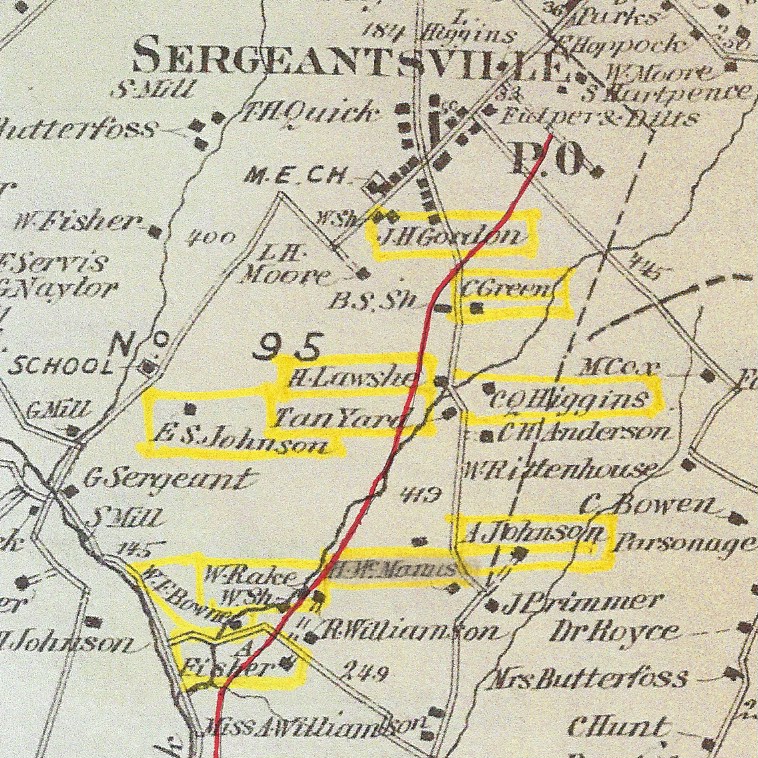 As mentioned in part one, the Beers Atlas was published the same year that the survey was made, allowing us to compare the two maps. Here is a detail of the Beers Atlas map showing the area being discussed in this article, with the named landowners highlighted in yellow and the proposed route being the dark red line.
The Atlas appears to show Route 523 running due north-south, when in fact it runs northeast/southwest. The road in the lower left corner is part of today’s Covered Bridge Road.
And here is a detail of the railroad survey map, showing the same general area.
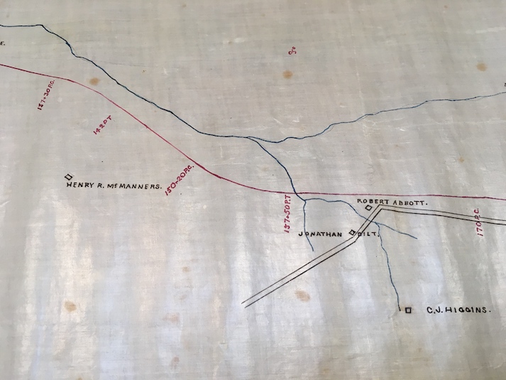 As you can see, only four owners are shown in this vicinity which is just south of Sergeantsville. The road shown is Route 523. The names shown are Henry R. McManners, Jonathan Dilts, Robert Abbott and C. J. Higgins. Omitted were Elias S. Johnson, Asher Johnson, and the Lawshe lot, presumably because although the line was to go through their property, their houses were not close to it.
Just south of the intersection of Covered Bridge Road and Lower Creek Road, a branch of the Wickecheoke Creek turns off toward the northeast. The rail line that had been following the Wickecheoke since Prallsville at this point veers off to run northeast toward Sergeantsville. After passing the property of William Rake, the line would have crossed the farm of Elias S. Johnson.
Elias S. Johnson & Sarah Wolverton
Beers: “E. Johnson;” Slaymaker: “Elias S. Johnson;”
Does not appear on the RR Survey Map.
Cramer Survey: “Elias Johnson” 100 acres, 150 baskets of peaches, used the ‘Penna’ RR, sold 5000 young peach trees, 500 lb grain/hay, used 900 lb lime, imported no coal, used 3 tons fertilizer, sold 350 cans of milk, 5 calves, 1400 lb pork, 10 bushels potatoes, and 35 bushels apples.
Elias and Sarah Johnson were mentioned in the previous article (The Route Not Taken, part one), but there is much more to say about them.
Elias S. Johnson (1810-1892) had deep roots in Delaware Township (see the Johnson Family Tree). He was the son of William Johnson and Urania Sergeant, and the grandson of Martin Johnson & Anna Trout and Loman Sergeant & Lydia Wolverton. His wife Sarah Wolverton (1819-1896) also had deep roots. Her parents were James P. Wolverton and Mary Ann Sergeant; her grandparents were John Wolverton and Rachel Quinby and Charles Sergeant and Sarah Green see The Wolverton Tree). Elias and Sarah were, in fact, second cousins. The couple married August 29, 1835 and had nine children; all but one grew to maturity.
In 1856, Joseph and Margaret Leigh sold to Elias S. Johnson for $5,555 a tract of 101 acres located between the Rosemont Sergeantsville Road and the Wickecheoke Creek.1 Johnson ran a lumber yard there, but in 1870 went into debt and had to assign his property to James L. Jones who in January 1870 sold the farm to Johnson’s father-in-law James Wolverton. In March 1870 Wolverton sold the farm back to the Johnsons. But in May of 1870, Johnson again assigned his assets to James L. Jones, and once again Jones sold the farm to James Wolverton.
Between the first sale and the second one, James P. Wolverton of Amwell wrote his will, on April 22, 1870, in which he left his home farm to son Charles and ordered his executors to sell the rest of his real estate. James P. Wolverton died on March 1871, still in possession of the Johnson farm. It was sold by his executors to his daughter Sarah on March 13, 1872 for $5,706.50. The Beers Atlas and railroad survey map both show “E. S. Johnson” at the farm, rather than using his wife’s name, despite the fact that the farm was owned by her, not her husband. That was generally the practice.
Elias S. Johnson died on March 4, 1892, age 81. At the time, Sarah was 73. This did not prevent her from marrying again. In 1896, she married the widower John Farley Shepherd, who was four years younger than she was.2 On Dec. 4, 1896, Sarah conveyed the Johnson farm to her new husband, and then died two years later.
Shepherd held onto to the farm until his death in 1903 when he was 80 years old. In 1905, his executor, James Rittenhouse, sold the farm to Shepherd’s youngest child, Israel P. Shepherd. (The amount paid was left blank in the deed.) This appears to have been a way for an executor to acquire the property he was acting on as trustee, because on the same day, Israel P. Shepherd & wife Arabella sold the farm back to James J. Rittenhouse, and as in the previous deed, the amount was also left blank. Rather suspicious.
The explanation is that Rittenhouse was Shepherd’s son-in-law, and Israel P. Shepherd’s brother-in-law. Rittenhouse was married to John F. and Mary C. Shepherd’s daughter Lily (1860-c.1910). Unfortunately, their marriage is not listed among the Hunterdon Marriage Records, but probably took place around 1885.
It fairly typical for deeds exchanged by family members in the 19th & 20th centuries to state a nominal sum for the consideration. Deeds were required by law to state some sort of consideration, and $1 was considered good enough. Because Rittenhouse & Shepherd had neglected to state a consideration, in 1910 a corrective deed was recorded with the consideration stated as one dollar.3
The next year, on March 29, 1911, James J. and Lily U. Rittenhouse sold the farm plus two other small lots to James Walter Allen, and for many years the place was referred to as the Allen farm.
Henry R. McManners & Sarah Ann Axford
Beers: “H. McManus;”
Survey Map & Slaymaker: “Henry R. McManners”
Cramer Survey: not listed
If you take another look at the two maps above, the Beers Atlas and the railroad survey map, you might notice that McManners/McManus is showing up in two different places. It took me awhile to figure that out. And it took me even longer to find an explanation.
Henry R. McManners (1814-1893), son of William McManness (1783-1853) & Sarah Dilts (1779-1851) grew up in the village of Headquarters, probably on today’s Zentek Road. The family name tended to morph from McManners to McManness to Manness to Manners. The Beers Atlas shows the name as McManus and the survey map as McManners. In later years, Henry’s name was usually spelled Manness, and that is the spelling on his gravestone, so that is the one I will use. It probably morphed into Manness to distinguish it from the Manners family of East Amwell.
William McManners, Sr. (1783-1853) may have been an immigrant from Ireland, but the census of 1850 states that he was born in New Jersey. In 1806, he married Sarah Dilts (1779-1851), daughter of Jacob Dilts and Martha Naylor, and had at least six children. We have the birth & death dates for William and Sarah because they were buried in the Sandy Ridge Cemetery.
Their third child, Henry Reading Manness was born in 1814, probably near Headquarters. He was a twin; his sister was Rachel Manners (1814-1896) who later married Samuel Case. Euphemia Manners, sister of Henry and Rachel, was Samuel Case’s first wife. The other notable sibling was Henry’s brother William W. Manness (1816-1893) who married Elvira Carpenter and will appear again shortly.
Henry R. Manness married Sarah Ann Axford (1820-1900) of Warren County in 1849. How they met is a question I cannot answer. Their first child, William D. Manness, was born in 1850, followed by six others, three of whom died as infants.
At some point between 1845 and 1853, some of the children of William and Sarah McManners moved to Providence in Luzerne County, Pennsylvania. William and Sarah remained in Headquarters. Their two youngest daughters, Maria and Harriet, also remained behind, Maria marrying George B. Heath, and Harriet marrying William Bowen.
In 1838, Henry R. Manness of Providence, PA bought a woodlot in Delaware Twp. from Asa & Mary Higgins, which had been part of the real estate of Nicholas B. Higgins deceased, and bordered land of his father, William McManners.4 Henry Manness sold that lot to John & Elias Conover of Headquarters in 1845, and on the same day, together with his brother William, bought a lot of 19.94 acres in Headquarters. At that time, Henry was living in Delaware Township, but his brother William had remained in Providence, PA. It was not long after this that Henry married Sarah Ann Axford.
In 1854, William and Elvirah Manners of Luzerne County, PA sold their undivided half share of the 19.94 acres in Headquarters to Henry R. Manners of Delaware Twp., and that is where Henry Manness lived until 1870, when he bought a tract of 40 acres on the road from Sergeantsville to Centre Bridge (Route 523).
It was sold to him for $3900 by William A. Naylor and wife Pamela as two tracts, the first of 40 acres which Naylor bought from Tobias Shadinger in 1844; and the second of 0.75 acres which Naylor bought from Joseph & Margaret Leigh in 1847.5 The second lot was probably an access way. Manness kept this farm until his death in 1893, after which it was sold to John D. Larison.
But that is not where he was shown in the Beers Atlas.
The lot purchased from William Naylor was located along the north side of Covered Bridge Road, which seems to be where the survey map shows him. But the Atlas shows the house of “McManus” fronting on Route 523. That was the location of the old Daniel Rockafellow farm, and it took some digging to find out how McManus could have acquired it. And in fact, he did not.
The location shown on the Beers Atlas was once the farm of Daniel Rockafellar, who with wife Rebecca Gano sold the 71+ acre farm in 1851, after which it went through a few owners until 1864, when Jacob and Sarah Hoff sold to William M. Manners of Scranton, PA, two separate lots, one of 21.62 acres, the other of 48.22 acres, for $5,188.38.6 I immediately began looking for the sale of this farm by William to his brother Henry. But no such sale ever took place.
William W. Manners and wife Elvira did not move to this Delaware Township property—they remained in Scranton. Henry McManus held on to his property along Covered Bridge Road, but appears to have lived on the property bought by his brother William.
Henry R. Manness, who was always identified as a farmer in the census records of 1860-1880, was one of the supporters of the proposed railroad. In January 1870, a meeting was held in Sergeantsville to promote the railroad and afterwards, “A committee was appointed to circulate petitions for signatures in support of the railroad.”7 Manners was a member of that committee.
After Henry McManness died on May 3, 1893 (age 79), his son Samuel Ervin Manners was given administration of the estate, and on April 7, 1894, offered at public sale the farm bordering lands of “W. W. Manness” and others, of about 40 acres. The notice, published in the Hunterdon Republican, stated that “improvements are a 2 1/2 story dwelling, barn, corn cribs and other outbuildings.” The property was bought by John D. Larison for only $900.8
Meanwhile, Henry’s brother William held onto the adjacent farm until his death in 1893. It was not until April 6, 1901 that the farm of 68.48 acres was sold to Joseph Lawshe of Delaware Township for $1,891.9
Jonathan M. Dilts & Elizabeth K. Wolverton
Survey Map: “Jonathan Dilts.”
Does not appear on Beers or Slaymaker.
Cramer Survey: not listed.
The Survey Map shows “Jonathan Dilts” on Route 523 just north of the Manness property, where Beer’s Atlas shows the Lawshe tannery. How did Dilts come to be the one shown there instead of Lawshe? Because Dilts was working the tannery, and Lawshe, who did own the property, was living elsewhere.
Jonathan M. Dilts (1826-after 1900) was the son of William P. Dilts & Mary Moore. In the 1863 Draft Registration record, he was 37 years old, residing in Delaware Township.
Well before the draft registration, Dilts was married to Elizabeth K. Wolverton, probably around 1853. (There was no marriage notice for the couple in any of the newspapers of the time.) She was one of the eight children of Job. A. Wolverton and Mary Lanning. This Wolverton family was very mobile. According to census records, they lived in Kingwood (1830), Delaware (1840), Bridgewater (1850), Flemington (1860), and Union Townships (1870).
By 1870, Jonathan Dilts was running the Lawshe tannery, located on Route 523 south of Sergeantsville. The census of that year shows that he owned no property but had $4,000 worth of personal assets. This may be why his name showed up on the railroad survey map.
Egbert T. Bush mentioned Dilts in his article, “Sergeantsville, A Town That Outlived Its Original Name” (see “A Sergeantsville History”). He wrote that Dilts rented the yard of the Lawshes and carried on business there until about 1882, and after Dilts left, there was no tanning done at that location. The 1880 census confirms that Dilts’ occupation was a tanner.
In 1876, Jonathan and Elizabeth Dilts bought a 23-acre lot from Joshua and Mary Primmer located on Sanford Road in Delaware Township. By that time their oldest child, Spencer L. Dilts, was 17 and their second child, Willis E. Dilts, was ten years younger.
Jonathan M. Dilts was a Chosen Freeholder from Delaware Twp. in 1876 and 1878, and in 1878 he oversaw construction of the Lockatong bridge on the Raven Rock Road. Sometime before 1893, he and Elizabeth had moved to Stockton, for that year Dilts was appointed postmaster of Stockton. The 1900 census showed that Dilts, then 73 years old, and wife Elizabeth K., then 76 years old, ran a cigar & tobacco store and took in tenants. Their son Willis, 31, a day laborer, was living in the same household with his own family (Elvira 32 and son H. Leroy, 11). Jonathan and Elizabeth obviously died sometime after 1900, but I have not found their death dates.
Robert Abbott & Rebecca C. Baldwin
RR Survey Map: “Robert Abbott.”
Does not appear on Beers Atlas, Slaymaker’s list or Cramer’s Survey
The next name on the survey map is similar to Jonathan Dilts in that he also does not get listed by either Beers or Slaymaker, or in the Cramer survey.
It appears that, like Dilts, Abbott was living on property owned by Henry Lawshe. But I am not at all sure about who he was. Robert Lanning Abbott (1796-1875), son of Isaac Abbott and Judith Lanning and husband of Elizabeth Wortman (1806-1889), lived in Branchburg and Bedminster in Somerset County, according to the census records of 1850-1870. Prior to that he owned a tavern lot in Readington. I found no deed for him for property in Delaware Township, and I also found no other Robert Abbott except for his son Robert Abbott, Jr. (1840-1905), who married in 1862 Rebecca C. Baldwin, and was listed as a resident of Delaware Township in the 1870 census.
This Robert Abbott, Jr. is probably the “R. Abbott” who also appeared on the survey map in another location, just east of Sergeantsville. He will appear in the next article in this series.
The Lawshe Tannery Lot
Beers: “H. Lawshe,” and “Tan Yard”
Not shown on the Survey Map or Slaymaker
Cramer Survey: “Lawshe estate” 140 acres, 4 tons coal, 525 lb or tons? Grain/hay sold, 500 tons lime, 3 tons fertilizer, 770 cans of milk, 11 calves sold, 30 sheep, 950 lb chicken, 500 lb pork. Note that these items probably pertain to Lawshe’s Bowne Station property, not to the tannery.
In 1844, Henry Lawshe bought the property that became known as the Lawshe tannery from David & Elizabeth Innes. It was located south of Sergeantsville on Route 523. Innes had purchased it from Cornelius H. Barber in 1837, and Barber got it from Peter Prall in 1835.10
An advertisement in the Hunterdon Gazette for April 22, 1835 declared that David Enos [sic], who was still in his 20’s at the time, had bought the tan yard and premises of Peter Prall on the road from Centre Bridge to Sergeantsville
“where he intends carrying on the Tanning Business in its several branches – and will keep constantly on hand for sale, at customary prices, SOLE LEATHER, Upper Leather, and Calfskins, of the best quality. He will also pay the highest prices for Bark.”
Afterwards, Innes bought a couple woodlots, as he was in need of bark for his tanning operation, but in 1844, he sold the tannery lot and several other properties in Delaware Township and moved to Champaign Co., Illinois, sometime before 1860.
Henry Lawshe, born 1798, was the son of Jacob Lawshe and Hannah Vansyckle, whom I wrote about in “The Lawshe House.” About 1820 he married Sarah Hoff Carter (1796-1868), the daughter of Henry Carter and Thisbe Calvin. Both Henry and Sarah grew up in Alexandria township, but moved to Delaware Township in 1832 when they purchased a considerable amount of land from John & Elias Conover in the Headquarters-Sandy Ridge area.
Henry and Sarah Lawshe sold the tannery lot in 1868 to their son Jacob R. Lawshe, charging him $4500 for it. It bordered the road from Sergeantsville to Centre Bridge, land late Daniel Rockafellow, Joseph Leigh, Cornelius Lake, and Robert Bonham.11 (See below)
The Cramer survey included an item for the “Lawshe estate,” which probably referred to the extensive property that Henry Lawshe owned near Bowne Station and where he lived until his death. Henry Lawshe died age 74 on October 12, 1872, not long before the railroad survey map was drawn.12 His wife Sarah Hoff Carter had predeceased him, dying age 71 on October 15, 1868. The couple were buried in the Lower Amwell Old Yard near Sandbrook.
Jacob R. Lawshe & Harriet F. Thatcher
Slaymaker: “Jacob Lawshe” [Jacob Sr. died 1865]
Beers Atlas: “H. Lawshe”
Survey Map: not shown (see Jonathan Dilts)
The Slaymaker list included “Jacob Lawshe,” but given the time frame (the 1870s) I doubt that he was referring to Jacob Lawshe, Sr., who died in 1865. More likely it was Jacob R. Lawshe, son of Henry and Sarah Lawshe.
As mentioned above, in 1868, Henry and Sarah Lawshe sold a lot of 25 acres to their youngest child Jacob Rynear Lawshe (1837-1914) for $4500. The deed13 described the property as bordering the road from Sergeantsville to Centre Bridge, land late Daniel Rockafellow, Joseph Leigh, Cornelius Lake, and Robert Bonham, and that it was the same lot that David & Elizabeth Innes had sold to Henry Lawshe in 1844.
About 1860, Jacob R. Lawshe married Harriet F. Thatcher (1838-1912), daughter of Jacob N. Thatcher and Sarah Ann Trout. In the 1870 census, Jacob was a 32-year-old farmer, his wife Harriet 32 keeping house. Their children were Theodore age 5 and Mary age 1. Also living with them was Jacob’s widowed father, Henry Lawshe, age 72, described as a retired farmer with real estate worth $12,000. But since Jonathan Dilts had taken over the tannery, it is not clear exactly where Jacob, Harriet and Henry Lawshe were living in 1870, on the tannery lot or on the Bowne Station farm.
After Henry Lawshe’s death in 1872, his heirs14 sold his property. Jacob R. & Harriet Lawshe moved to Newark shortly after Henry’s death. In 1874, Jacob and Harriet sold the tannery lot to Cyrus L. Axtell of Newark, who in 1883, sold it to George T. Bush.
Cornelius Quick Higgins & Elizabeth Bartolette
Survey Map: “C. J. Higgins”
Slaymaker: not listed.
Beers Atlas: “C. Q. Higgins” across from the Lawshe Tan Yard.
Cramer Survey: not listed.
The survey map shows “C. J. Higgins” but there was no such person. There was, however, a Cornelius Quick Higgins (1817-1883) who purchased the farm of Daniel Rockafellow on Route 523 in 1851. Higgins sold the farm five years later to George Hoff, who’s son Jacob Hoff sold it to William W. McManness in 1864.
After selling the old Rockafellar farm to George Hoff, Cornelius Q. Higgins bought another farm, across the road from the Lawshe tannery, from Peter & Leah Bowlby. The Bowlbys had purchased that property from Peter & Hester Green.15 Higgins remained there for the rest of his life. His heirs sold it in 1884 to Abraham Lawshe.
Cornelius Quick Higgins (1817-1883) was the son of Judiah Higgins (1785-1824) and Mary Quick (1792-1858). Given that his father Judiah died when Cornelius was only seven years old, it is a question what his upbringing was like. In fact, the youngest of Judiah Higgins’ children, daughter Ellen or Eleanor, was born only two months before he died.
Who assisted the widow Mary Quick in bringing up her seven children? The uncles mostly died young. Asher Higgins died in 1823 age 36; uncle Richard Higgins died in 1829, age 35; and Jonathan Higgins died in 1840, age 50.
Judiah Higgins had died with considerable real estate in Raritan Township, on the border with Delaware Township, which did not get distributed and sold until 1846. By that time, Cornelius Quick Higgins had come of age and married (in 1841) Elizabeth Rush Bartolette. She was born in 1813 to Rev. Charles Bartolette and Martha Rush of Sandy Ridge. As far as I can tell, the couple had only one child, Charles B. Higgins, born 1843, who married Mary H. Kitchen of Frenchtown in 1868.
Higgins did not get too involved in local matters, although he was active in the Temperance Association at Sergeantsville in 1866, when he was named one of the managers.16
Higgins was a farmer all his life. He died in Delaware Township in 1883, age 66. In 1884, his widow Elizabeth and her son Charles and his wife Mary, all residents of Frenchtown, sold the Higgins property to Abraham L. Lawshe of Franklin Township for $4100.17 It consisted of 42.10 acres bordering Asher Johnson and George W. Sharp, among others. The deed had no recital.
Asher Johnson & Mary Ann Reading
Beers: “A. Johnson”
Slaymaker: “Charles Johnson”
RR Survey Map: not listed
Cramer Survey: not listed.
In 1825, Asher Johnson (1803-1884), son of Martin Johnson and Anna Trout (see The Johnson Tree), was married to Mary Ann Reading (1809-1880), daughter of John Reading and Martha Sergeant. They had 14 children, from 1827 to 1852. Three or four of them died as infants, many of the rest married into well-known families: Phillips, Blackwell, Hagaman, Hope, Lewis, Prall and Wagner.
Asher Johnson, whose parents owned a large property near Raven Rock, struck out on his own and built a new tavern at Centre Bridge (now Stockton) in 1832 at the end of Bridge Street (see “A Stockton Inn History”). But, as Egbert T. Bush wrote,18 in 1849, news got out of a new railroad (to be known as the Belvidere Delaware Railroad) to run along the river. Johnson, fearing he would be put out of business, sold the tavern and bought a farm not far south of Sergeantsville.
Asher Johnson bought the farm of 71.5 acres from Edward & Elizabeth Hunt on March 26, 1849 for $3,700.19 Three days later, Johnson bought a smaller lot of 28.5 acres for $1,000 from Tobias & Catharine Shadinger, which had been sold to them by Edward & Elizabeth Hunt.20 Both properties were originally part of the John Severns tract. After 1819, the property had changed hands frequently until Asher Johnson bought it; he kept the farm until his death in 1884, after which it was conveyed to his son Holcombe Johnson. Today Sugar Maple Jerseys is located there.
Johnson was a very prosperous farmer. The census of 1870 showed he owned $8,000 worth of real estate and $1200 worth of personal property. At that time, his son Theodore, the youngest child, was 17, working on the farm. Second to youngest son Holcombe was 21, also working on the farm. The farm was adjacent to land of Joshua Primmer.
In 1885, a year after Asher Johnson’s death, his son Holcombe West Johnson bought from the executors of the estate the homestead farm of 28.5 acres and the other farm of 71.5 acres.21 Unfortunately, H. W. Johnson went into debt and the property was sold at a sheriff’s sale in 1895.
Next landowner along the proposed route is Charles Green, whose story is even more complicated than the ones dealt with here. See “The Route Not Taken, part three.”
Footnotes:
- Many years later it was known as the farm of Donald and Beverly Jones. ↩
- I had written about Shepherd in the previous article, The Route Not Taken, part one. ↩
- H.C. Deed Book 297 p. 537. ↩
- H.C. Deed Book 70 p. 207. ↩
- H. C. Deed 145-678. Note the Henry Manness’ mother-in-law was named Martha Naylor (b. c. 1760). I wondered if she could have been related to the William Naylor who sold the property. William A. Naylor (c.1814-1896) was the son of Robert Naylor Sr. (c.1760-1828) & Sarah Larison (c.1760-c.1843). Martha Naylor Manness could have been a sibling of Robert Naylor’s, but I have not found evidence for that. ↩
- H. C. Deed Book 130 p. 571. ↩
- Hunterdon Republican, Jan. 13, 1870. ↩
- H. C. Deed Book 239 p. 511. ↩
- H. C. Deed Book 261 p. 546. ↩
- The deed from Prall was not recorded, but the conveyance was recited in the deed from Barber to Innes. David Innes was married to Elizabeth Britton (c.1813-1907). She is no doubt connected with the Amwell Britton/Brittain family, but I have not been able to identify her parents. Also, I have not found the death date for David Innes or the identity of his parents. ↩
- H. C. Deed Book 141 p. 754. ↩
- Surprisingly, there was no obituary for him in either the Hunterdon Republican or the Hunterdon Democrat. ↩
- H.C. Book 141 p. 754. ↩
- William & Rebecca Lawshe and Spencer & Reuby A. Lawshe of Winebago, IL; George & Francena Lawshe and Lewis H. & Ann Eliza Lawshe and Jacob R. & Harriet T. Lawshe of Newark, NJ; and Hannah V. Dilts & husband John C. Dilts of Delaware Twp. ↩
- I will have more to say about the Greens in the next installment. ↩
- Hunterdon Republican, March 23, 1866. ↩
- H. C. Deed Book 205 p. 65. ↩
- “When Stockton Was Not So Dry, part two”. ↩
- H.C. Deed Book 94 p. 380. ↩
- H.C. Deed Book 94 p.378. ↩
- H. C. Deed Book 210-005. For more on Holcombe Johnson and his wife Sarah C. Prall, see “The Sutton Farm, part two.” ↩
Nancy Heath
December 21, 2019 @ 3:55 pm
Thanks for the great article, and particularly the section about Henry McManners and wife Sarah Ann Axford. I’m descended from Henry’s sister Maria, and have been researching the origins of this family. Regarding your Note 5, Martha Naylor was actually Henry’s maternal grandmother, not his mother-in-law. I have been unable to connect Martha to other Hunterdon County Naylors. However, one clue is that the death certificate for Martha’s youngest child, Charlotte Dilts Williamson, states that her mother was born in New England.
Also, I have not seen any evidence suggesting that Henry’s father William McManners was an immigrant from Ireland. His 1850 census entry gives his birthplace as New Jersey, and his death register entry says he was born in Amwell Township. I’m wondering what might indicate that he was an Irish immigrant?
Marfy Goodspeed
December 21, 2019 @ 5:37 pm
Thanks, Nancy. I will have to take a closer look at the Naylors and Wm McManners to answer your questions, if I can.
Marfy Goodspeed
January 14, 2020 @ 12:44 pm
Well, much to my dismay, I cannot put my finger on where I got that reference to Wm McManners being an Irish immigrant. And there is no doubt about it, the 1850 census says born in NJ. Let’s just settle on he was an immigrant to Hunterdon Co. Thanks for the heads up.
Kyle Keiderling
December 24, 2019 @ 1:01 pm
I always enjoy your articles and the extensive research that you pursue.
Marfy Goodspeed
December 24, 2019 @ 1:31 pm
Many thanks.