
The Road from Howell’s Mills and
John Reading’s Plantation to Trenton
Recently I wrote about the earliest known public road in Hunterdon County, recorded in January 1721/22 (The Amwell Road of 1721.) The next earliest, at least for the southern part of the county, was dated 1736, and followed part of the earlier route.
I will give the record in full, and then try to identify each course along the route.1
To All to whom These presents Shall Come
Whereas the Inhabitants of the Township of Amwell in the County of Hunterdon finding themselves to lye under Great Inconveniencys and Disadvantages by the Stoping up Turning and the Totall neglect of Clearing up of a Road for near Thirty Years past hath been deemed & esteemed a lawfull Road of four Rodd wide and Accordingly was Cleared up & from time repaired But by some in advertency the Return of the sd road is not to be found as in the time of laying out of the same the Law then in force in that Case required to be made
NOW KNOW Ye that we the Surveyers of Roads for the sd County of Hunterdon for this present Year 1736 being requested by the said Township of Amwell that is of those who find themselves aggrieved by Reason aforesd to lay them out a four Rodd Road at the nearest & best way into ye Road leading to Trenton
Which Road so requested to be layd out Begins Where the Road as it hath been formerly used and beaten from Trenton to a Mill late Daniel Howell or the plantation formerly John Reading, being at the Intersection of a Road leading from the South Branch of Rarinton to Delaware River at a Redd Oak Marked Tree Thence along the Beaten & frequented Road to the Westward of Johannes Whimmers Plantation thence along his fence & the old beaten Road and in the line of Jacob Gordown & Samll Barns Land Thence along the Road by the Land of Isaac Decow & Company & near to the plantation where Bartholomew Thatcher dwells Thence along the beaten Road over Aliashokkin Brook & across the Road leading to the ferry upon the Delaware River and Crossing ye sd Alishokken Brook again as the Road hath been formerly Used to the Division of ye Land of George Green & Sall. Green Thence along the Lane and the beaten & frequented Road toward Trenton untill it comes to a Forked Maple tree standing on the East side thereof Thence nearly South East by marked trees to a White Oak forked about five foot from the Ground Thence to the East side of Stephen Burrowghs Field to Chesnut Bridge Runn about Five Rodd below the sd Steven Burrows Fence Thence as the Trees are Marked to the Foot of the Hill before John Acre’s House to the Old frequented Road Thence along the same through Jonathan Smiths Plantation to the East Side of his Orchard and so along the Old frequented Road to Abraham Larow Land and by his Fence to the Meeting of ye Road commonly called Mallazatick Road which leads to Trenton.
What this return had to say about the road in years past is most interesting:
Whereas the Inhabitants of the Township of Amwell in the County of Hunterdon finding themselves to lye under Great Inconveniencys and Disadvantages by the Stoping up Turning and the Totall neglect of Clearing up of a Road for near Thirty Years past hath been deemed & esteemed a lawfull Road of four Rodd wide and Accordingly was Cleared up & from time repaired But by some in advertency the Return of the sd road is not to be found as in the time of laying out of the same the Law then in force in that Case required to be made
“Near thirty years” means the road must have been in use since about the time of the creation of Amwell Township in 1708. It was “deemed and esteemed a lawfull road,” because the original record was missing in 1736. Part of the road certainly was recorded in 1722, in the minutes of the Court of Common Pleas (Bk 1 p. 7); perhaps the writer was not aware of that. However, a record for a part of the road discussed here has never been found. This is the section, leading to John Reading’s plantation and Howell’s Ferry, that was in use by 1708 when Reading and Howell had settled in Amwell.
NOW KNOW Ye that we the Surveyers of Roads for the sd County of Hunterdon for this present Year 1736 being requested by the said Township of Amwell that is of those who find themselves aggrieved by Reason aforesd to lay them out a four Rodd Road at the nearest & best way into ye Road leading to Trenton
The “Road leading into Trenton” is the old Trenton-Easton Turnpike, Route 579, which was an important part of the earlier road return. And here is where the road is to begin:
Which Road so requested to be layd out Begins Where the Road as it hath been formerly used and beaten from Trenton to a Mill late Daniel Howell or the plantation formerly John Reading, being at the Intersection of a Road leading from the South Branch of Rarinton to Delaware River at a Redd Oak Marked Tree
“The Mill late Daniel Howell” belonged to the Daniel Howell who died in 1733 (between September 9th when he wrote his will and October 24th when it was recorded). His mill was located near Prallsville. He was also known for the ferry he ran at today’s Stockton.
The road “from Trenton to a mill late Daniel Howell or the plantation formerly John Reading” is a very general description and not much help to us. There are several possible routes. But the fact that the description was so vague tells us that the writer must have been referring to a very well-known road.
Part of that well-known road was the Trenton-Easton Turnpike, or the road from the Indian villages on the Assunpink to the Forks of the Delaware; in other words, County Route 579. However, 579 does not run to Howell’s Ferry (Stockton). This well-known road had to take a turn to the west to get to Reading’s Plantation, near present-day Rosemont, or the mills at Prallsville. The ‘road leading from the South Branch to the Delaware River’ is Route 523, the route to Howell’s Mills and Ferry.
So, the road should begin at the intersection of Routes 579 and 523, just as the earlier road did. In 1721, the landmark for this beginning point was “Pettit’s Plantation.” But in 1736 there is no mention of Petit, or of Daniel Robins, who also owned land at the intersection. In fact, this 1736 record does not say that the road begins at that intersection. It simply says it begins in the road that runs from the South Branch to the Delaware River. So the beginning could be anywhere along that road.
Thence along the Beaten & frequented Road to the Westward of Johannes Whimmers Plantation
Johannes Whimmer/Wimmer and his plantation are the key to locating this road. So where was Mr. Wimmer’s plantation? According to Egbert T. Bush,2 on December 5, 1732, Johannes Whimmer purchased from John Van Vorst a farm of 130 acres, bordering land sold by Eden Marselison to Johannes Johnson, and land of Denis Lake. (How I wish Mr. Bush had used footnotes.) He learned this from a recital in a later deed which stated that on September 6, 1742, Johannes Wimmer sold his farm of 130 acres to Caleb Farley for £210. In 1748, Caleb Farley sold the 130 acres he had bought from Johannes Wimmer to his brother-in-law (husband of Farley’s sister Sarah) Peter Prall.3
D. Stanton Hammond has located Caleb Farley on a tract of land that straddles Buchanan Road. His notation reads: “Caleb Farlee (Mtge 1 – p. 253) 1782 120 A.” This was part of the large plantation of 700 acres first surveyed to Benjamin Field in 1701,4 and later sold to John Way of Newtown, N.Y., who then sold it to Eden Marselison and John Van Vorst, who later divided it between them.
By plotting out the metes and bounds from the mortgage, I found the Wimmer-Farlee plantation straddling Lambertville-Headquarters Road, and bounded on the north by today’s Buchanan Road (which did not exist in 1736). The property was bordered by John Mullin, Abraham Deremer, Abraham Hagaman, Aaron Prall, John Barber, Isaac Gano and Dr. Dimsdale. This is consistent with Bush’s description in which Whimmer’s 130 acres bordered land sold by Eden Marselison to Johannes Johnson.
Johannes Johnson was the father-in-law of Samuel Barber, and the father of Alida Johnson Barber, to whom Caleb Farlee had to pay £96.10.9 in one year, as part of the mortgage of 1782. Farlee also had to pay £219.16.0 to John Barber, £47.14.2 to Catharine Johnson, and £48.2.10 to Sarah Johnson, for a total of £410.
Johannes Johnson must have been one of the earliest settlers in Amwell Township. He was an Amwell freeholder in 1741, and was a “cooper of Amwell” when he wrote his will on November 10, 1756 in which he named sons-in-law John Barber and Caleb Farley his executors. He named his wife Maria, and daughters Alida Barber (wife of Samuel), Magdalene Barber (wife of John), and Geertrude Farley, wife of Caleb Farley. He also named his grandchildren, children of his deceased son Johannes: Johannis, Sari, Susana and Cathrina. From these names it is obvious this was a German family.
Johannes Johnson and Johannes Wimmer probably came to Amwell at about the same time. I expect they were among the German immigrants who fled the Palatine region of Germany in the early 18th century, and settled in New York and New Jersey. A very large number of them settled in Hunterdon County.
As for Dennis Lake, I can say nothing. I have a lot of information on the Lake family of Hunterdon County, and never once have I come across a Dennis, except in this record. (He is not listed in ‘Colonial Conveyances.’) And as for Johannes Wimmer, after the sale of his plantation to Caleb Farley, he disappears from Hunterdon County records. I suppose he moved on, as so many colonial families did.
So, now that we have located Wimmer’s plantation, we can start a map. Let’s return to the road record:
Thence along the Beaten & frequented Road to the Westward of Johannes Whimmers Plantation
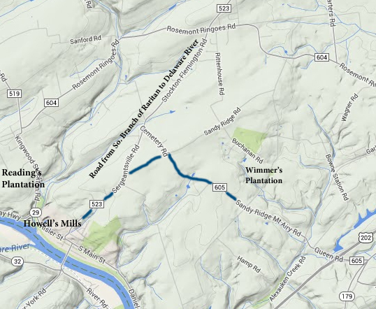
Westward of the Wimmer plantation has to be Sandy Ridge-Mt. Airy Road. How did the road get to Wimmer’s plantation from Route 523? It is my belief that the turn-off from Route 523 was at Sandy Ridge Road. This route shows up in other early documents, and is the most convenient way to get to Sandy Ridge-Mt. Airy Road from Howell’s Ferry. At the summit of Sandy Ridge Road, where the old Baptist Church now stands, the 1736 road then turned right onto Sandy Ridge-Mt. Airy Road, and proceeded southeast.
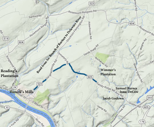
thence along his [Wimmer’s] fence & the old beaten Road and in the line of Jacob Gordown & Samll Barns Land
These two landowners, Jacob Godown & Samuel Barnes, definitely put us on the Sandy Ridge-Mt. Airy Road. Jacob Godown owned a tract of land along that road, as described in a deed of 1779 in which Evan Godown sold 111 acres to Andrew and Lavinia Larason.5 The deed’s recital stated that Godown had purchased from William Biddle on February 20/21, 1707 a tract of land bordering “the Great Road” and the “line of an old survey,” and also on December 26, 1718 bought from John Reading an additional 30 acres adjoining the lot bought from Biddle, bordering Bartholomew Thatcher, the Great Road and the “Allishockin Brook.” Apparently the total came to 230 acres. This tract of land can be located easily on the southwest side of Sandy Ridge-Mt. Airy Road.
There was a Jacob Godown, born c.1700, who married Mary Evans c.1722. They may have had daughter Catharine (c.1724-1777) who married Albertus Ringo, and son Evans (c.1723-bef. 1779). But we are concerned with an earlier Jacob Godown, who was listed in the account of the estate of Joseph Adams of Burlington as early as 1703. (Keep in mind that Amwell was part of Burlington until 1714.)
In March 1733, Jacob Godown mortgaged his plantation of 200 acres beginning in the King’s Road in line of an old survey, in Amwell, excepting the southeasterly half part “where son Jacob now dwells;” the mortgage was satisfied in 1744.6 The King’s Road was Sandy Ridge-Mt. Airy Rd. The “old survey” was the one made for William Biddle in 1701. Unfortunately, the mortgage does not mention bordering owners, nor does it say anything about land purchases made in 1707 and 1718. The mortgage metes & bounds are a little vague, but by lining the sides up with the Biddle tract and the road, the property matches the up with the lot sold by Evan Godown in 1779. This mortgage also tells us that by 1733, the road was considered a King’s Road, despite the fact that in 1736, it was suffering from neglect.
Samuel Barnes, “Gentleman,” was an interesting character. Describing all I have found about him (and not found) would take too much space for this article. His parents and spouse are unknown to me. He was probably born around 1695, and by 1718 was identified as Samuel Barnes, Gent., reflecting his wealth and standing. The term was used in a deed of 1771, for 100 acres sold by Robert Barns, Samuel’s son, to William Taylor, land which Samuel Barns, Gent., purchased in 1719 from Andrew Phillips out of the Biddle tract.7 This 100 acres bordered the “King’s Road” on the northeast, opposite the land of Jacob Godown.
Like so many of the other people mentioned here, Samuel Barnes also mortgaged his property to the Hunterdon County Loan Office in 1737. He mortgaged 100 acres on March 20, 1737, located on the King’s Road, for £16.8
Samuel Barnes figures in an interesting deed of 1748 in which he bordered property acquired by John Reading, which Reading sold to Johannes Bosenberg.9 Part of this property was owned by Isaac Decow in 1722. The recital in this deed is long and confusing, as many transactions took place, often with several joint purchasers, but the property itself was definitely located along Sandy Ridge-Mt. Airy Road, on either side of the Alexauken Creek. Isaac DeCow, according to this deed, sold his share of the property to John Reading in 1741. Reading then sold it in 1748 in which it was described as “Beginning at the southeasterly side of a branch of the Alias Hoking Brook a little above the King’s Road leading to Trenton.”
Isaac DeCow did not live in Amwell Township. He was a land investor who probably lived in Burlington or Trenton.10 The DeCou/DeCow family is an interesting one, but I do not have enough information to straighten out all the Isaacs, Jacobs and Josephs who invested in Hunterdon County land. But at least now we can place Jacob Godown, Samuel Barnes and Isaac DeCow on the map.
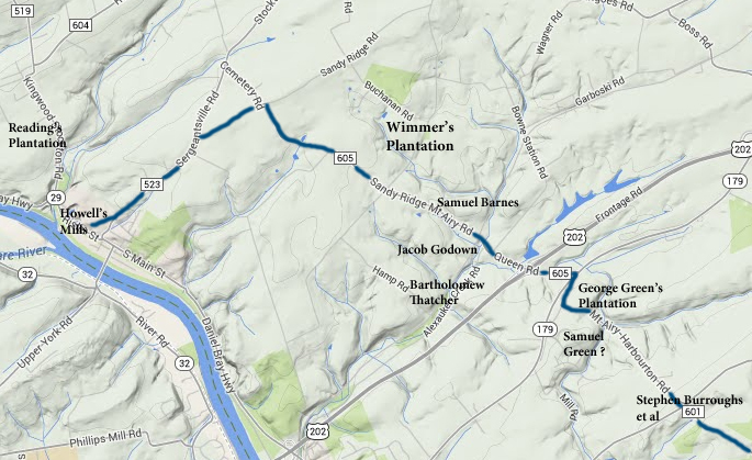
Thence along the Road by the Land of Isaac Decow & Company & near to the plantation where Bartholomew Thatcher dwells
This course is the most frustrating to me, because if we depend on information from the Hammond Map, it makes no sense, and I really do want to know where Bartholomew Thatcher was living. Hammond Map F (at D/4, for those of you who use the index) shows Bartholomew Thatcher just north of the Alexauken Creek on the tract of 300 acres bordering the Delaware River, surveyed originally to Edward Kemp and John Reading.
This is not where I want Thatcher to be—it’s way off course. But then, Bartholomew Thatcher was one of those people who was not scrupulous about recording his deeds. It’s very hard to pin him down. In 1740, he bordered 100 acres in Amwell mortgaged by Gideon Rouser.11 The only other bordering owner to this tract besides Thatcher was John Ruckman. No mention of the Kings Road or the Great Road, or even the Alexauken Creek. So I cannot say exactly where this lot was located. There is some reason to think that Thomas Ruckman owned land near Mt. Airy, but that does not help us.
There is one clue in the deed previously mentioned for land of Jacob Godown (Deed Bk 3 p. 297). The recital mentions 30 acres bought from John Reading. It borders Bartholomew Thatcher on the southwest. Based on what I’ve already decided about where the Godown tract was located, this would put Thatcher somewhat southwest of the Sandy Ridge-Mt. Airy Road (which becomes Queen Road in West Amwell). This is slightly off course, but then, there were not that many resident landowners along the route in 1736. Like Johannes Wimmer, the surveyors may have been indicating the nearest landowner available.12
To describe the life of Bartholomew Thatcher would require a separate post. There were several men of that name who lived in Hunterdon in the 18th century, but the one most likely to have owned property here was born about 1670, married to Elizabeth and father of 12 children. In the 1690s he shows up in Bucks County records, and apparently left in some haste in 1696 due to litigation. Next record I have of him is in 1708 when he was a carpenter living in Hopewell Township, and he and his brother Joseph sold their father’s property in Middletown Township, Bucks County. I have no record of him moving to Amwell before 1736, but he was counted as an Amwell freeholder in 1741. I also have found no estate for him, but Thatcher researchers say he died in 1771 in Kingwood Township.
Thence along the beaten Road over Aliashokkin Brook & across the Road leading to the ferry upon the Delaware River
The ferry was Coryell’s Ferry at Lambertville. The road leading to Coryell’s Ferry was the Old York Road or Route 179. Note that at this point, the Sandy Ridge-Mt. Airy Road has become Queen Road in West Amwell.
and Crossing ye sd Alishokken Brook again as the Road hath been formerly Used to the Division of ye Land of George Green & Sall. Green
This is curious—crossing the Alexauken twice. The maps give no hint of a road that might have done that, unless the first mentioned Alexauken was the main creek and the second was a branch of that creek—there is such a branch running south from the main creek.
As for the division of land between George Green and Samuel Green, here we have another problem. I have no record of Samuel Green in this vicinity. But we do know where George Green’s plantation was. Green was the only person whose name appeared in both the 1722 and 1736 road records.13 His plantation is shown on Hammond Map F as lying southeast of Mt. Airy, along the Mt. Airy-Harbourton Road. George Green’s property also showed up bordering that 1,146-acre tract of land originally surveyed to Robert Dimsdale and then resurveyed to his sons William and John Dimsdale in 1722 and recorded in 1725.14 This huge tract included all of the village of Mt. Airy and also most of the Old York Road towards Lambertville.15
Samuel Green had invested in land near Mt. Airy in partnership with John Reading in 1710.16 But he had released his share to Reading in 1712, so that was not the property bordering George Green in 1736. A likely possibility is the tract on the southwest of Green’s plantation which Hammond shows was surveyed to Richard Bull and John Clark in 1697.17 After Richard Bull died intestate in 1722, much of his property was transferred to his sister Sarah, who was the wife of Samuel Green. That is probably what happened with this tract of 270 acres. Unfortunately, Samuel Green was very lax about recording deeds, which is so surprising for a deputy surveyor.
Thence along the Lane and the beaten & frequented Road toward Trenton untill it comes to a Forked Maple tree standing on the East side thereof
This beaten road to Trenton is the Mt. Airy-Harbourton Road. The following people owned land along this stretch of road: Stephen Burroughs, John Akers, Jonathan Smith and Abraham Larew. To discuss the route along these properties requires a separate article, and a greater knowledge of Hopewell Township history than I possess. Don Cornelius, archivist at the State Archives, informs me that a gold mine of information on Hopewell history can be found in the Betsey Erickson papers at the State Archives. That would be the place to start. What I do know from previous research is that Abraham Larew owned land in or near the village of Harbourton, which is the end point of this road.
Here is the final map. (If you visit The Amwell Road of 1721 you will see the earlier version of this road, as well as several later 18th century maps of the area.)
Postscript: Researching Johannes Wimmer
There was another early land record that named a Johannes Wynder who bordered property of Edward Farrel (or Harrel) in 1737.18 This was located at the junction of Sandy Ridge-Mt. Airy Road and Brookville Hollow Road, putting Whynder southwest of Sandy Ridge-Mt. Airy Rd. This is the wrong place for the road record, and I doubt that Whynder and Whimmer were the same people. But stranger spelling mistakes have been found.
Curiously, Hammond identifies a tract of land belonging to Thomas Winder in or near the Richard Bull 270 acres mentioned above. In 1734, Thomas Winder of Hopewell died intestate. Administration was granted to the widow Rebecca on May 23, 1734. In her account of March 10, 1746, she mentioned John and Thomas Winder, sons of the deceased. Was this the same Johannes Winder who bordered Edward Farrel/Harrel? And was it the same as the Johannes Wimmer/Whimmer who sold land to Caleb Farlee? I rather think not.
Another approach to locating the Wimmer farm is to look at the deeds of John Van Vorst. He and Eden Marselison purchased 700 acres from John Way of Newtown, Long Island on February 15, 1722 (which Way had bought from Benjamin Field’s estate).19 It bordered the large tract of land surveyed to William Biddle.
In 1737, Van Vorst mortgaged 185 acres out of his share of those 700 acres. This lot bordered Biddle on the east and Samuel Green on the west.20 Van Vorst also appears as a bordering owner that year to Richard Green, Samuel Green and the lot owned by Edward Farrel (or Harrel).21 The Green surveys are too difficult to plot (which calls into question the surveying skills of Samuel Green). The Farrel survey shows Van Vorst at the southern end of the Benjamin Field tract (Block 60 lot 1).
In 1747, John Van Vorst sold 174 acres to Abraham Deremer. Some of this land might have been part of a lot that Deremer sold to Jacob Larowe who sold it to Abraham Hagaman in 1761.22 This was on the northeast side of Sandy Ridge-Mt. Airy Road, across from the Farrel lot of 50 acres. But all we have learned is that Johannes Whynder’s property was probably sold to him by John Van Vorst.
Footnotes:
- This road record was shown to me many years ago in the form of a typed transcript found in records at the Hunterdon Co. Historical Society. Too bad I was too naïve to write down exactly where the transcript was taken from, because I have failed so far to find the original record. The list of possible sources is long—and every one of them so far has turned up empty. I have checked H.C. Road Books, H.C. Road Petitions, Court of Common Pleas Minutes, Special Deeds, Freeholders Minute Book, Amwell Minute Book A, Hunterdon Archives, and Snell’s History of Hunterdon (where I found the 1721 record). Don Cornelius has checked the archives at the Hunterdon Co. Historical Society without success. Some day that record will turn up. ↩
- “Glen Eppele Once Owned by Soldier of the Revolution,” Hunterdon Co. Democrat, January 14, 1932. This article, as originally published by me in 2012, requires updating in light of information gathered for this present article. ↩
- Mr. Bush wrote that the deed he was quoting from was found in the records of the Secretary of State, which is where colonial period deeds were held in the 1930s. Today they are at the NJ State Archives. I believe the deed he is referring to is found in Book K p. 245, and the next time I get to Trenton, I will verify that. ↩
- West Jersey Proprietors, Deed Book B2 p. 702. ↩
- Hunterdon Co. Deed Book 3 p. 297. ↩
- HCLO 1737, No. 47. ↩
- Recital in Deed 10-283. ↩
- HCLO 1737, B-30. He made annual payments of principal and interest every April from 1738 through 1751. In 1752, he paid in March, and the last payment was made May 5, 1753. The amounts paid don’t appear to add up to £16. There is no notation of cancellation on the document. ↩
- WJP GG 216. ↩
- On June 28, 1735 he was named in the will of Jacob DeCou of Mansfield Township, Burlington Co. Here is a quandary. He was either the son of Jacob, who was named sole executor, or he was the brother of Jacob DeCou, as described in an interesting bequest. Jacob left to his brother Isaac the sum of £30 “which he got of John Hogg of Holden, he being my father’s trustee, the money belonging to me notwithstanding my said brother got the same by a forged letter.” Jacob’s will was recorded on March 1, 1736. The inventory stated that he died on February 21, 1735/36. ↩
- HCLO 105, 1740. ↩
- Egbert T. Bush also mentions Thatcher in this location in his article “Dilts Corner Once Scene of Some Industry” (Oct. 2, 1930). ↩
- The Amwell Road of 1721. ↩
- WJP Survey Book A p. 125. ↩
- There was another survey of property for George Green on the books, this one for 610 acres bordering “a branch of the Pophanunck River, a Pond, and a great hill. He also got a mortgage for this tract in 1737. Too bad this property was in Sussex Co. (Survey in WJP Bk M1 p. 57a; mortgage in HCLO 1737, No. 49; the mortgage was paid off by 1741.) ↩
- WJP Bk GG p. 216. ↩
- WJP Survey Bk A p. 37? ↩
- HCLO No. 78. ↩
- WJP Book AG p. 72. ↩
- HCLO 1737, No. 92. ↩
- HCLO No. 74, 77, 78. ↩
- per Deed 301-581. ↩
Mark Valente
February 7, 2015 @ 11:21 am
Very informative. Thank you for your research.