The Old Stone Signpost at Plum Brook
Plus Some Thoughts on Road Names
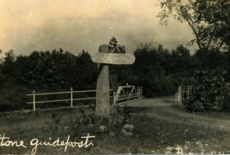
Recently my friend Paul Kurzenberger brought me a photograph of a postcard showing the location of the old stone signpost that once stood at the intersection of Ferry Road and Locktown-Flemington Road.

You might not recognize the location. The view is from the west side of the intersection, looking east. The sign reads on the left “Locktown and Kingwood,” and on the right “Sergeantsville and Stockton.” That right section of the sign is actually turned to the south towards Ferry Road. Probably concealed from this angle is a third sign pointing east toward Flemington.
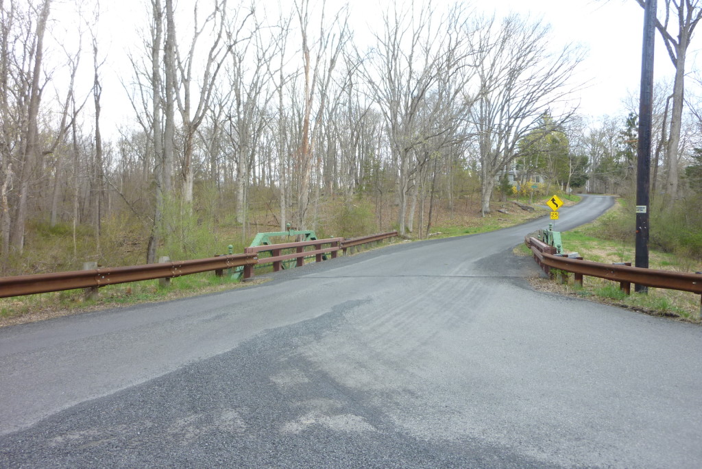
Recently, I tried to get a photo from the same vantage point, but of course that is not really possible. Still—here it is for comparison. As you see, so much has changed, including not only a vast widening of the road, but considerable growth of trees, and some radical “improvements” to the bridge.

The post was moved away from this location by Bob Reed in the 1990s. By that time, its handsome signs were gone, and large trucks and school buses were having a hard time navigating around it. It was feared the post would eventually be destroyed, so it was moved to the side of the road near the intersection with Stone Signpost Road.
At one time, sign posts like this were fairly common. They were suitable for the days when people relied on horses to get around, but became annoying obstacles once the automobile took over. And yet, there was a time when people were unhappy at the lack of stone posts. On December 1, 1804, the state legislature had passed a law permitting the counties “to erect post or stone guides at the intersection of public roads with the name or names of the most noted or public places to which such road may lead, and of such other places as may be thought proper, with the estimated number of miles to such places respectively in figures: and also mile stones at the end of each mile on said roads &c.” This quote was taken from a letter written to the True American, a Trenton newspaper, on April 14, 1806. The writer was unhappy that the counties had not immediately set to work putting up signposts. Their neglect left travelers “without guides to direct their steps, or stones to beguile the weariness of the way.” The writer signed his name “Guide Post.” (In the 19th century it was common for letters to the editor to be signed with pseudonyms.)
Eventually, many posts were erected, only to come down again, replaced by our modern road signs. These road signs were late 2th century improvements. Prior to that, roads were identified by their routes, for instance “the road from Stockton to Sergeantsville,” which had previously been called “the road from Howell’s Ferry to Skunktown.” If the road name changed, it was because the names of the towns they connected had changed. Travelers unfamiliar with these roads had to hope someone would direct them to their destination, since signs and signposts were few and far between.
When roads were first surveyed, they were not given names. The survey usually describes where the road begins and ends. For instance, Pavlica Road began in “The Road from Sergeantsville to Locktown” and ended in “The Road from Green Sergeant’s Mills to Tunis Mires’ Mills.” That is what Pine Hill Road used to be known as. The Raven Rock-Rosemont Road was surveyed in 1777. It began in the Great Road near Isaac Rettinghousen (which was the Rittenhouse Tavern in Rosemont; the “Great Road” was Route 519) and ended in the road to “the Ferry on the Delaware River by the name of Price’s Ferry.” This last road is today’s Federal Twist Road.
Charlie Jurgensen, whose family moved to Sergeantsville in 1913 when he was a child, remembered that nobody referred to road names in the old days. When you talked about where you were going, you referred to the family you were going to see. That was enough since all farm locations were generally known. So if you were going to see the Pavlicas, everyone knew where you were going. Now we have Pavlica Road. The same for Meszaros Road and Buchanan Road, Rittenhouse Road, Zentek Road, Haines Road, Wagner Road, Worman Road, Svoboda Road and Yard Road.
Even the 1920s census shows that most roads were identified by their destinations. Examples in Delaware Township were: The Road from Harmony School, The Flemington-Stockton Road, The Road from Stump Tavern to Duck’s Flat (Strimples Mill Road), The Road from Covered Bridge to Rosemont, The Road West from Buchanan’s Hill, The Road from Harmony School. Other names are more recognizable, like Covered Bridge Road, Locktown-Sergeantsville Road, Whiskey Lane, Worman Road, Ferry Road, the Trenton Road, River Road, etc.
One of the most remarkable roads in the 1920 census was called: “English Tommy Robinson Road.” Really. Residents along that road in Delaware Township were Rasmius G. Goouley[?], Emanuel Jurgenson, both immigrants from Denmark, Nahasson Knechel, from Pennsylvania, Charles Opdyke and George W. Bird. I believe this road was Hewitt Road, north of Rosemont. The Beers Atlas of 1873 shows “T. Robinson” at Block 19 lot 46 on Hewitt Road.
Tommy Robinson was indeed an English immigrant to Hunterdon County. He was born about 1813. According to his death certificate (he died in 1895), he came to New Jersey about 1845 and first appears in the census records in 1850, living in Delaware Township with wife Margaret (born in NJ) and four children. The oldest child, William was age 9, suggesting that Robinson was in NJ by 1840 and must have married that year. (No wedding notice was published in either the Gazette or the Democrat.) A search of deeds will give us a better idea of when Tommy Robinson took up residence on or near Hewitt Road. Robinson died on November 24, 1895 at the age of 82. The fact that 25 years after Robinson died, the road was still was named for him suggests that Tommy Robinson must have been a memorable character. His widow Margaret died on November 10, 1900, age 95.
Roger Harris
April 27, 2014 @ 11:57 am
I live on Covered Bridge Road. I’ve seen it referred to as “the road from Sandy Ridge Church to Covered Bridge” or “the road from Sandy Ridge Church to Sergeants Mills”. Makes me think that Lower Creek Road (the part to the southwest of Covered Bridge Rd) must have been more of a secondary road or simply a private trail at some point.
I’ve also seen (what we now call Rte 523) referred to as “the road from Sergeantsville to Sandy Ridge Church”. I guess there was a significant rerouting at some point there. Does this figure in the history of the Pauch farm? – as that would have been on either side of “the road from Sergeantsville to Sandy Ridge Church”.
Marfy Goodspeed
April 27, 2014 @ 1:35 pm
Roger, that “road from Sergeantsville to Sandy Ridge Church might have been Sandy Ridge Road, rather than Rte 523. Hard to say. Road routes were rather different in old times, so it can be difficult to understand what was meant, even tho folks at the time must have known exactly what was meant. The road names you mention suggest that when people referred to a ‘road,’ they really meant several roads that got you from one place to another.
Virginia Mickle
November 27, 2015 @ 3:23 pm
Marfy, do you have any information about Pecks Ferry at Plum Creek? I have Pecks in my lineage but from Connecticut. I’ve not come across any reference to Pecks in this area until I saw the photo of the fingerboard on our road.
Virginia