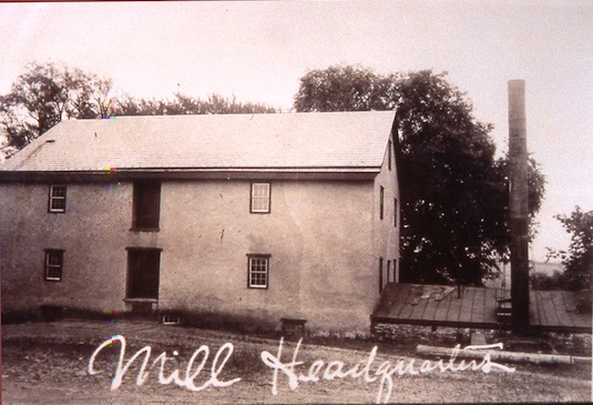
I was going to publish here an article I wrote about the Headquarters mill that first appeared on The Delaware Township Post in 2006. But like many writers, I can never leave well enough alone. Since Samuel Green figures in the history of the village of Headquarters, if not the mill itself, it seems appropriate to focus on the earliest history of the mill.
First Question: Who Built the Mill?
The original mill at Headquarters was probably the first to be built in what is now Delaware Township, if we can rely on the date stone, which shows the year 1735. However, if you accept Prallsville as part of Delaware Township, which it was until 1898, then Headquarters has the second-oldest mill. We have no solid date for when a mill was erected at Prallsville. We do know that the first owner of that land, John Reading, gave a square mile of property to his daughter Mary and her husband Daniel Howell at the time of their marriage, about 1710, and that Howell is thought to have established a mill north of his ferry in what is today Stockton, but back then was known as Howell’s Ferry. Daniel Howell mentioned his mill in his will of 1733, at which time it was undergoing “reparations.”
After the land called Headquarters was purchased from Indian sachems in 1703, the first surveys began to be made around 1711. The first survey for a tract of 540 acres was made for John Ladd in 1712, but later records suggest that the next owner was Samuel Green the Surveyor. Green was one of the first residents of Amwell township—he was named the first tax collector for Amwell in 1709. Green’s home at that time has never been located because his property holdings were so extensive. But three of the four children known to be born to Green’s wife Sarah Bull were born in Amwell Township about 1711-1715.
According to a marriage license recorded at Trenton on May 28, 1730, the oldest child, Sarah (thought to have been born about 1708 in Philadelphia) married Benjamin Severns. About 1737, the second child, Margaret, married John Opdycke of Maidenhead. Both sons-in-law were given large tracts of land at Headquarters by Samuel Green.
It was in 1737 that John Opdycke mortgaged 450 acres bordering Benjamin Severns, and also bordered land mortgaged by Samuel Green. Severns also mortgaged land that year, 499 acres bordering Samuel Green and John Opdycke. Unfortunately, the descriptions of these properties are very inaccurate, making it impossible to be certain of their exact locations. Samuel Green would seem to be the most likely person to have made those surveys; I can only think he must have been in a hurry—perhaps because he was preparing to leave the area. He was in so much of a hurry that he mistakenly identified the creek that ran through the properties as a “branch of the Delaware” when in fact “Caponockons Creek” (as identified in Hammond’s Map) is considered part of the Third Branch of the Neshanic, which drains into the Raritan River. The mortgage to Opdycke named the creek “Tokhokonetkong,” which gives you an idea of how much trouble Europeans had learning the Lenape language.
Evidence that I am not the only one having problems with these metes and bounds comes from the diary of John Reading Jr., well-known surveyor of West New Jersey and member of the Governor’s Council. An entry in Reading’s Journal dated  February 2, 1746 reads (with apologies for Reading’s shorthand):
“At the request of Sam’l Green by Jos’r [Johannes?] Opdike I [John Reading] sent him a D’ft [draft] and ffield works of Benj: Severns & his land and of the divisions thereof that the sd Green might be enabled to settle the affair between them. To which D’ft & ffieldworks he gave me 2/6. At the same time wrote a letter to sd Green.”
“Benj: Severns” (c.1710-1792) was a son-in-law of Samuel Green’s, just as John Opdycke was. It appears that Severns and Opdycke had a disagreement over their property lines. This may have come to a head when Severns was preparing to sell his property before removing from Amwell Township to join his father-in-law Samuel Green in Greenwich Township in old Sussex County. Green left Amwell Twp. about the time he married his third wife, Hannah Wright, in 1738. He was about 63 years old by then, and started a completely new family in what became Warren County. A second entry in Reading’s Journal, dated two days later, reads thus:
“Benj. Severns obtained from me a certificate in the affair between him and Opdike containing as underneath vizt: thse may certify that I have been employed as a surv’r by Benj: Severns & Jos’p Opdike to run round the lines of their Plant’s: in Amwell conveyed to them by Sam’l Green their Father in Law and [illegible] divide by protraction of Courses and Distances if I miss not to contain in the whole 495 A’s strict measure. And also that I ran the Dividing line between Y’m and find that there is contained in Benjs: lines 37 A’s more yn in Jos’as [Johannes]. [signed] John Reading Ffeb ye 4th 1746.”
If only those surveys had been preserved.
The question remains, who built the first mill in 1735? Was it Benjamin Severns or John Opdycke? The mill’s date stone of 1735 is two years before Opdycke is thought to have married Margaret Green, but five years after Severns married Sarah Green. Opdycke is usually credited, since he had ownership of the property in 1763 when he sold it to Joseph Howell. Severns seems to have left Amwell by 1757, possibly as early as 1749, for he failed to record earmarks in Amwell that year. Deeds and mortgages of the 1770s and 1780s refer to “land formerly Benjamin Severns” being the southern half of the village of Headquarters. This suggests that Severns may have been the original builder of the property known as White Hall, on the southwest corner of the intersection of County Route 604 and Lambertville-Headquarters Road.
On the other hand, it appears from a deed of 17751 that Opdycke had owned a considerable part of Headquarters for a long time. In that deed, Opdycke was conveying land to his son Thomas which was described as “all that part of his old farm and plantation given to him the said John Opdycke by Samuel Green.” There is yet another possibility—that Samuel Green built the first mill. But I suspect not, since Green was by then spending much of his time surveying in the far northern reaches of West New Jersey, and is not known to have ever built a mill.
Here is an old photograph of the mill in the 19th century.

One final argument in favor of Opdycke over Severns is the fact that Benjamin Severns and wife Sarah left their son John behind in Amwell, and John’s property, which he got from his father, ran along the southern side of Route 604, from Headquarters to Sergeantsville, running south of the tract owned by Amos Thatcher. I have not found a deed that shows Severns owning land north of Route 604, which makes his ownership of the Headquarters Mill unlikely. Could the mill have been part of the dispute between Opdycke and Severns that John Reading was asked to resolve? Probably not.
With Samuel Green and Benjamin Severns relocated to Warren County, we are left with the Opdycke family at Headquarters and John Opdycke running the mill, at least for a few years. But he seems to have shifted his attention to the Wickecheoke by the 1750s. The Wickecheoke was a far more reliable creek than Caponockon‚Äôs was, even with a mill pond and mill race. We know that Opdycke had relocated to the Wickecheoke by 1754 because he built a handsome stone house there and laid in a datestone that reads: ” J O¬† & M O 1754″. The JO = John Opdycke, MO = Margaret Opdycke.
For some reason, after 1754 Opdycke moved back to Headquarters. He may have decided to hire a miller to manage the Wickecheoke mill. John Opdycke is said to have built the farmhouse located on the southeast corner of Route 604 and Lambertville-Headquarters Road in 1744. But another source gives the date of 1758. The Opdycke Genealogy states he was living there during the Revolution.
A descendant of John Opdycke was quoted in the Opdycke Genealogy saying that Opdycke
“first built and lived in the stone house on his farm which now belongs to Mrs. Samuel Higgins, near Headquarters. He built “Whitehall,” also “Headquarters House” where he kept a store, and a mill close by. He [also] laid out the Opdycke graveyard at Headquarters and he and his family are buried there.”2
Addendum (Aug. 21, 2010):¬† Mrs. Samuel Higgins was Mary E. Reading (1846- ?), second wife of Samuel M. Higgins (1811-1877), the son of Nicholas B. Higgins (1787-1851) who inherited the farm on Lambertville-Headquarters Road from his father Nathaniel Higgins (1760-1823). Nathaniel Higgins bought¬† 94.26 acres from the estate of Benjamin Tyson dec’d in 1808. Mrs. Samuel M. Higgins was identified as Marietta Reading in the Reading genealogy written by Leach,3, which states that she died on December 25, 1850.
This farm is not the same as the Skeuse farm at the southeast corner of Rte 604 and Lambertville-Headquarters Road, which was the farm that John Opdycke Esq. spent his last years in. The Higgins farm was south of the Opdycke farm.
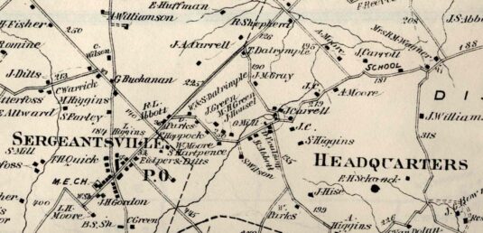
Here is a detail from the Beers Atlas of 1873. It shows the location of the grist mill “G. Mill” across the road from “J. Carrell,” and the Higgins farm as “S. Higgins” just above the name Headquarters.

Footnotes:
- H.C. Deed Book 30 p.37. ↩
- Charles Wilson Opdyke, Leonard E. Opdycke, Wm. S. Opdyke, The Op Dyck Genealogy, printed by Weed, Parsons & Co. for the authors, 1889p. 218. ↩
- Josiah Granville Leach, LLB, Genealogical and Biographical Memorials of the Reading, Howell, Yerkes,Watts, Latham and Elkins Families, Philadelphia: J. B. Lippincott Co., 1898, p. 99 ↩