This Delaware River ferry was located on the Pennsylvania side at the village of Lumberton in Solebury Township, which is easily confused with Lumberville, further north.1 On the New Jersey side, the ferry began at Johnson’s Tavern near the end of Federal Twist Road, about ¾ mile south of Bull’s Island.
It was known as Rose’s Ferry in the mid-18th century, that is, John Rose, whose father Stophel had bought a large amount of land in Solebury Township. William Skelton bought the part of John Rose’s property that contained the ferry, and then sold it in 1771 to John Kugler, a German immigrant. During the Revolution, Kugler and his wife Susanna (Worthington) were accused of harboring spies for the British army and were jailed in Newtown on April 6, 1780. They were later that year released on bail of £15,000 each and allowed to continue operation of the ferry. But Kugler decided to sell it instead. The buyer in 1782 was George Warne, of Hunterdon County, who in turn sold land in Kingwood Township to Kugler, who relocated there, and died in 1812. His wife Susanna lived to the great age of 92, dying in 1834. After George Warne died in 1792, his executors sold the ferry property to Joseph Hart for £1300, at which time it became known as Hart’s Ferry.
While the ferry was being run on the Pennsylvania side by the Kuglers and Geo. Warne, it was operated on the New Jersey side by Jacob McClain from 1775 to 1786. When Federal Twist Road was surveyed in 1775, it began at “Jacob McClain’s Ferry on the Delaware River.” He undoubtedly had the opportunity to ferry militia and Continental troops across the Delaware, and probably British troops also, given the Kuglers’ loyalist inclinations.
In 1785, the ferry was taken over by Robert Thorn(e), who also bought McClain’s land nearby.2 The Reading Howell Map of 1785 shows Warne’s Ferry on the Pennsylvania side of the river, and Thorne’s Ferry on the New Jersey side. Thorne had been a landholder in Amwell Township in 1780, when he was taxed on 62 acres and a fishery. He was taxed there again in 1786, still on 62 acres and a fishery. By 1790, he was only taxed on 20 acres, and still no ferry. The only men taxed on a ferry in Amwell Township that year were Joseph Griggs and John Price, neither of whom are associated with Painter’s ferry. Perhaps Robert Thorne was taxed in Pennsylvania. There was no estate for him in Hunterdon County either.
B. F. Fackenthal wrote that Jacob Painter became the owner in April 1796, while “Reuben Thomas” took over the Pennsylvania side, at which time it became known as Painter’s Ferry.3 But William Davis in his History of Bucks County claims that Painter took over the ferry in 1796 with “Reuben Thorne” as his partner. I can’t help but wonder if Reuben Thomas, Reuben Thorne and Robert Thorne were all the same person.
Robert Thorne was succeeded by Thomas Rose (or Ross). Rose had begun as a miller in Buckingham, Pennsylvania. He was probably related to Stophel and John Rose who had run the Pennsylvania side of the ferry before the Revolution. I have no dates for Thomas Rose’s tenure. He may have overlapped with Jacob Painter, who took over the ferry from the Pennsylvania side.
Jacob Painter bought the old Rose property on Cuttalossa Creek and was living in Solebury Township in 1797 when he purchased 107 acres in Kingwood from Jacob Kyple Jr.4. A road return of 1801 mentions “Painter’s Ferry.” Jacob Painter was a successful entrepreneur who ran a tavern, a storehouse, and a grist and sawmill on the Pennsylvania side of the river. After he died in 1805, his Pennsylvania property was sold to Joseph Kugler, who I am guessing was the son of John and Susannah Kugler.
The most intriguing item for me in Fackenthal ‘s paper was mention of a map of 1811 showing “Saxton’s Ferry,” at the Painter’s Ferry location, just south of “Saxtonville.” I have not located the map that Fackenthal referred to.5 This is the earliest use of the name Saxtonville that I know of, and the first time I have heard of Nathaniel Saxton taking over operation of the ferry.
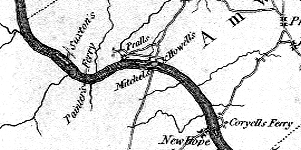
Paul Schopp informs me that Reading Howell made a map of the Delaware River in 1811 (an update of his 1785 and 1792 maps). It shows “Saxton F.” for Saxton’s Ferry, but no “Saxtonville.” Paul sent me a detail of another map, made in 1812 by William Watson.6 It is quite wonderful–part of it is shown below:

The road going straight up the middle is today’s Co. Rte 523, running through Stockton, but back in 1812, it would have been known as Prallsville. Mitchell’s Ferry is on the Pennsylvania side and Howell’s Ferry on the New Jersey side. The map is very explicit about Painter’s Ferry near Bulls’ Island being known by that name on both sides of the river. Further upriver, “Saxton’s” appears to designate the location of the old mill, but it could be taken to mean the entre settlement along that very short stretch of road.
Painter’s New Jersey property, 80 acres plus the ferry, was acquired by Moses Quinby soon after Painter’s death, for on May 8, 1805, Quinby sold 90 acres running along the east side of Federal Twist Road to John Wilson for $2400.7 Wilson may have conveyed the property to Nathaniel Saxton although I have no recorded deed to prove that. Saxton probably took over after he bought his share of the mill at Bull’s Island in 1809. The property ended up belonging to Martin Johnson, who also owned the farm just west of Federal Twist Road. From then on it was known as Johnson’s Ferry.
About the time that Nathaniel Saxton sold his interests in the Saxtonville mill lot in 1814, the ferry that once bore his name probably closed down, for that was the year that a bridge was built at Centre Bridge (now Stockton). It certainly reduced, if not eliminated, ferry traffic in the surrounding area. When Martin Johnson wrote his will in 1825, bequeathing the property to his son William, he made no mention of a ferry.
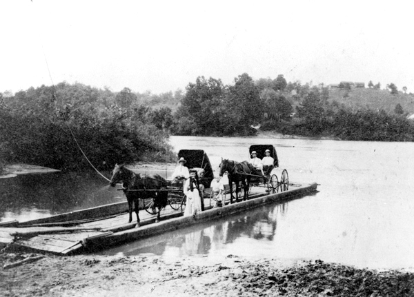
Here is a photograph from Google Images that shows what a Delaware River ferry probably looked like in the early 19th century, even though this was taken in the early 20th. Allowances must also be made for the style of dress and the handsome buggies.

Note: This is a corrective post to a previous article, Reading Howell’s Map of 1785, in which I gave an incorrect history of this ferry, due to a lack of information. Goes to show–speculation about history can lead one into blind alleys. Thanks to Betty Davis for introducing me to the Fackenthal paper, especially the section on the “Lumberton Ferry.” I have removed a short history about the ferry from the Reading Howell post in order to present a revised version here, reserving the right to update and revise again as more information comes to me.
Addendum, 6/22/2012: I just came across an advertisement in the October 30, 1833 issue of the Hunterdon Co. Gazette for the sale of the estate of Thomas Little deceased, including:
All that REAL ESTATE, Well known by the name of PAINTER’S FERRY, on the Delaware, situate immediately on the river stage road and Pennsylvania Canal – containing About 119 ACRES. . . . The above property is worth the attention of an enterprising person, as it offers many inducements to make it a very valuable property. The Pennsylvania Canal running on one side with a bridge and wharf to accommodate the ferry, and immediately opposite on the other side of the river, the Delaware and Raritan Canal is nearly completed – making a complete water navigation to Philadelphia or New York.
This is particularly interesting because it suggests that the ferry was either still running or could be made to run, despite the canal which was under construction at this time.
Addendum, 2/13/2015: A survey map drawn in 1819 by Edward Welsted intended to depict the earliest landowners at Raven Rock does not show Painter’s Ferry. The Ferr was located at the end of a property line dividing land of Martin Johnson and the rest of Peter Fretwell’s proprietary tract of 650 acres. For more on this intriguing map, see “Return to Raven Rock.”
Footnotes:
- Lumberton, at the mouth of the Cuttalossa Creek, was named around 1838-40, in recognition of the successful sawmill operated there by John Kenderdine. It is thought that the name was chosen to compete with the older village of Lumberville upriver. ↩
- Hunterdon Mortgage Bk 1 p.303, for 100 acres, Robert Thorne to Jacob McClain. ↩
- Benjamin Franklin Fackenthal, “Improving Navigation on the Delaware River, With Some Account of Its Ferries, Canals, Bridges and Floods,” a paper read before the Bucks Co. Historical Society in 1922. ↩
- Hunterdon Co. Mortgage 2-262, in which Painter’s home was written as “Salisbury, Bucks Co.” ↩
- I do not have the complete paper by Fackenthal, so I cannot say if he cited this map in his notes. ↩
- William Watson, “A Map of the State of New Jersey,” 1812. Engraved by W. Harrison, Philadelphia, Pennsylvania ↩
- Hunterdon Co. Deed 11-248 ↩
Eren Hatton
September 12, 2020 @ 3:02 pm
I was curious about this ferry it says Painter’s & also Hatton Ferry. I have Painters & Hatton family ancestors.