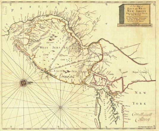
John Worlidge’s Map
This wonderful map is on file at the Library of Congress. According to the Rutgers Special Collections website, the map is dated 1706. That may be when the map was published, but it seems to depict properties as they were in 1690.
Whatever the date, it is interesting for the way it shows the location of Dr. Daniel Coxe’s holdings in West Jersey. The map shows a large area designated for Doctor Coxe south of Trenton, along the Delaware River. It also includes a large tract with the jagged boundary immediately recognizable as the northern boundary of Hopewell Township. The tract runs south to the “Road from York to Delaware Falls,” from the Delaware River to the Millstone River. This tract is indicated on the Hammond Map as “Gov. Daniel Coxe’s 30,000-acre (1707) Hopewell Patent.”
Rule to Indemnify Daniel Coxe
At the September 1688 meeting of the Council of West Jersey Proprietors, it was agreed that
every proprietor, and every person interested in proprieties, shall pay to the use of Daniel Coxe, to any person appointed to receive it, as a reimbursement for the money laid out by him, in the Indian purchase lately made in the lower counties, the sum of twelve shillings and six pence for every thousand acres, and so proportionably to be taken up out of that purchase; the first year to begin the first day of April last past, and from that time twelve months, to advance eighteen pence upon every year ensuing, until the time that the money aforesaid to be paid for; the land to be laid out within the bounds of the same purchase, as consideration for the monies disbursed by the said Daniel Coxe in the said Indian purchase of the whole tract, which, by the surveyor Andrew Robeson, is computed to be three hundred thousand acres of good land, capable and worthy of improvements; which money being paid, the party so paying shall be acquitted of all other payments on the consideration aforesaid
“2. That the surveyor for the time being, be engaged not to set out any land within the limits of this Indian purchase, until the money above-mentioned be paid and secured as abovesaid.
“3. And it is further agreed that for the land taken up by order of the said Dr. Coxe, above the falls of Delaware, every proprietor taking up any part thereof, shall pay to Dr. Coxe, or his order, the sum of twenty-five shillings per thousand acres, and two shillings and six pence yearly consideration, ’till the money be paid.”[Samuel Smith, The History of the Colony of Nova-Caesaria or New Jersey, 1765, pp.202-03.]
Clearly the land north of Trenton (the falls of the Delaware) was considered far more valuable than land south of it. And it appears that Coxe had the proprietors in the palm of his hand.
At this meeting (Sept. 6, 1688), Samuel Jennings was named commissioner to examine and record deeds for Burlington County and issue warrants to the surveyor general, Andrew Robeson, on behalf of the Proprietors. And John Reading was named to that position for Gloucester County. They also resolved that:
no person or persons whatsoever, shall presume to purchase any land from the Indians, without the consent of this council first obtained, otherwise to be prosecuted as our common enemy.”
This was closing the barn door after the horse had left, since I’m pretty certain that Adlord Bowde went ahead and made his deal with the Lenape well before informing the proprietors of what he had done. Undoubtedly, the West Jersey proprietors had a very uneasy relationship with Gov. Coxe.
Correction: I’m not so sure, after going more carefully through the papers published by G. D. Scull, that the statement by Coxe was written in 1688. It is hard to determine what was written on that date and what was written later in 1692.

