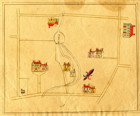
As I have mentioned in previous posts,1 many wonderful documents can be found in the Cathers-Davison collection that has recently been donated to the Hunterdon County Historical Society. I was very fortunate to get a look at some of them beforehand, and among the earliest documents was a gem.

Such a wonderful drawing, but to my dismay, there is nothing written on the front or the back to identify where this little hamlet is located. I suppose the artist figured that anyone looking at the picture would know right away where it was and would have no need of labels.
As you can see, I like it so much, I’ve made it the heading for my website, but what place it depicts has me and others truly stumped. I thought it might be Prallsville since it was found among papers pertaining to Prallsville families, but it just isn’t right for that place.
If you have an idea of where this might be, please let us know. Clearly it has to be somewhere near an old mill site, but it could just as well be in Bucks County as in Hunterdon. A mystery waiting to be solved.
Marshall Lake
October 4, 2014 @ 3:02 pm
Just thinking out loud here …
Does the Cathers-Davison collection center on a certain area in Hunterdon County?
The hamlet could, of course, not exist any longer.
“M. Pond” is a clue. Is there a list of ponds in Hunterdon County? Manny’s Pond?
ralph a. Applegate
June 21, 2015 @ 12:45 am
M.pond is definitely only clue , I believe , which may help you ? I recall, I believe , several ponds in Central, Southern , now ,but then, Mercer Co.? Could it have been a Pond connected with Millstone River, I really call it Brooke!
Alberta James Daw
October 6, 2014 @ 11:56 am
…and I believe that each house is rendered truly within the cartographer’s ability. If only someone has drawings of a long ago family home!
Alberta Daw (Bertie)
Elaine Oakes
October 6, 2014 @ 6:34 pm
No guesses where, but the building in the upper right looks like a public building of some kind (school, inn?). The single lines resemble property boundries, the small area cut off in the lower left corner and the way the line around the larger area with the big house makes angled turns. Except for the details of the houses and the absence of directional labels at the angles it resembles a plat map from a deed.
ArtS
October 11, 2014 @ 9:49 pm
Just a thought: Mercer County was part of Hunterdon County until 1838. Could this little hamlet be ‘south of the border’?
ralph a. Applegate
June 21, 2015 @ 1:01 am
Speaking of Willson’s , I have a Mary (About 1710 ) born somewhere within sight of Wilmington , since the author has problems as I do with this search ?
ralph a. Applegate
June 21, 2015 @ 1:13 am
Since spokes were mentioned I would like to know about that and how and when wheels were made because some early “stagecoaches ” about before 1688 left South Amboy and went thru (And I can say where ?)! They likely stopped at George Rescarrick’s Tavern in Cranbury after 1700 on their way to Bordentown and Burlington , and they could have been in 12 inches of water on Cranbury Brook before a grist mill was built there about 1736 !