This post is a return to Egbert T. Bush’s article “Sandy Ridge Long a Farm Community,” the first half of which was published last month (“Sandy Ridge, part four.”) Today I resume with Mr. Bush’s description of a small lot on Sandy Ridge Road, where once stood a house that is now long gone. (Block 54 Lot 10).
On a 3-acre lot north of the road and a few rods east of Bush’s driveway, stood an old-time dwelling, now gone and almost forgotten. Who built it and when it was built are alike unknown. There at one time lived Robert McCauley, whose chief occupation was making and vending fanning mills. In 1858 this lot was sold by George B. Holcombe, Sheriff, to Asher Salter,who conveyed it to Adam Williamson in 1863.1
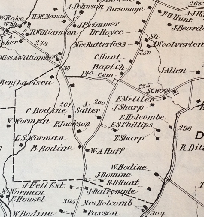 Detail from Beers Atlas, showing Sandy Ridge Road running from Route 523 (property of W. A. Huff), then past Phillips and Salter to the Church Cemetery and intersection with Cemetery Road, then continuing on past the Church, and properties belonging to C. Hunt, Mrs. Butterfoss, Dr. Royce and the Parsonage on the west side of the road (the map is not oriented to the north), and A. Woolverton and his shop on the east side. Note also “P. Jackson” and “C. Bodine” on Route 523.
Mr. Bush missed a story here. Actually, a couple stories. First of all, Robert Macauley/McCauley, born about 1821 in Pennsylvania, was a man of several occupations. He was a teacher at the Vandolah School on Sandy Ridge-Mt. Airy Road, a merchant (1850 census) and a master carpenter (1860 census). I suppose a producer of fanning mills could be called a carpenter, and if he was selling them, a merchant.
Macauley married Nancy West in 1844. She was born May 27, 1828 to William West and Lavina Roberson of Kingwood Township. (Thanks to Kay Larsen for identifying Nancy West Macauley.) The census of 1860 counted four of their six children, Amanda 9, Lucinda 7, Lavina 6 and George 3. Their two sons, James and Wilson Macauley, were living elsewhere.
When Mr. Bush wrote “Who built it [the house] and when are alike unknown,” I had to, of course, look for Macauley’s deeds to see what I could learn. On February 22, 1851, he bought a one-acre lot on the Sandy Ridge Road from Robert Sharp, which Robert Sharp had bought from the estate of William Sharp, deceased. On March 31 of the same year, Macauley bought an additional two acres from Alexander P. Holcombe, also part of the lands of William Sharp, dec’d. I don’t believe that Robert Sharp or Alexander Holcombe lived on these small lots. More likely it was Macauley who was the builder of the house. Especially since the Cornell Map of 1851 shows no house at all along the north side of Sandy Ridge Road.
The other story here is that Robert and Nancy Macauley sold their combined 3-acre lot to Rebecca Brown, “late Butterfoss,” on March 27, 1856 for $826.50, which is much more than Macauley paid for the two lots.2 In fact, it was probably too much because two years later, Rebecca was taken to court for unpaid debts. Her lot was seized and sold by Sheriff Holcombe to Asher Salter, as Mr. Bush wrote.
Meanwhile, the Macauley’s had moved to Stockton where they remained until his death in 1865. Nancy Macauley died sometime after 1870.
Rebecca Brown was the daughter of Daniel Butterfoss, Sr. and Esther Ent. She was born either August 4, 1801 or August 25, 1804, and it is thought that around 1830 or later, she married Charles Brown or Bowne. But there is no record of him, of their marriage, of his death, or her death. Where Rebecca went after losing her Sandy Ridge home is a question I cannot answer. Most likely she moved in with a relative.
Back to Mr. Bush:
In 1869 it [the Macauley lot] was again sold by the Sheriff, this time Joseph P. Lake, to Jonathan Cowdrick, who conveyed it to Solomon Holcombe in the same year. Holcombe sold this lot and two additional acres of land to Cyrenius Bearder in 1870. The dwelling burned down soon after, the contents even to important papers all going with it.
In 1871 Bearder—father of George Bearder and Annie Bodine of Flemington—conveyed the 5 acres to Rev. George Young, and it became merged with the Lambert Moore farm, then owned by Cornelius Bodine.
Cyrenus Bearder
Cyrenius or Cyrenus Bearder (1831-1903) was the youngest child of Andrew Bearder and Mary Besson, who lived up on Locktown Flemington Road. In 1861 he married Emily Bosenbury (born 1842), daughter of Jonas Bosenbury and Ann Wolverton of Franklin Township. Cyrenus had been working on the farm of Emily’s father in the 1860 census.
The sale by Solomon Holcombe to Cyrenius Bearder took place on March 30, 1870, in which a lot of three acres bordering the Sandy Ridge – Centre Bridge Road, and an adjacent two-acre lot bordering the same road were sold for $800. According to the Hunterdon Republican, the Bearder house was destroyed by fire on February 1, 1871. It “burned to the ground, including its contents.” The paper mentioned that it was thought the fire “originated from the stove pipe.” On August 14, 1871, the Bearders managed to sell the five-acre lot to Rev. George Young for $675.3
As a reflection of Bearder’s loss, the 1880 census listed him and his family living in Raritan Township, with Bearder an unemployed laborer. He and Emily had four children by the time of the fire. Two more were born later, George Bearder and Annie Bearder Bodine. In the 1900 census, Cyrenius Bearder 68 was back in Delaware Township, renting a home from William Bodine. Living with him were his wife Elizabeth and his son George, age 20. Daughter Annie married George L. Bodine (1870-1953), son of Samuel Bodine and Jane Bird, in 1899 at the Locktown Christian Church.
Cyrenus Bearder died in1903, age 71. His widow Emily went to live with her daughter Elizabeth and son-in-law Burroughs Parent, in Lambertville, and died sometime after 1910.
The Jackson Lot
Bush wrote that the Macauley house was sold to Asher Salter. The Beers Atlas of 1873 shows “A. Salter” in possession of a house on the north side of Sandy Ridge Road. It shows another house nearby, fronting on Route 523. The house is labeled “P. Jackson,” and the tax map shows that the lot ran all the way from Sandy Ridge Road north to Route 523.
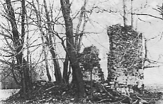 If you are driving north on Route 523, not far from the intersection with Sandy Ridge Road, you will go through a pretty sharp curve to the right, and just at that point there is a clump of trees close to the road. I’ve always wondered about that. Then I got a look at the Historic Sites Survey for Delaware Township (1977) and saw what is no longer there—the ruins of an old stone house. That was at one time the home of Peter and Elizabeth Jackson.
Here is how the property was described in the Historic Sites Survey:
“At an angle to the road are the crumbling rubble stone ruins of what appears to have been a small two-story, single-pile dwelling [one-room deep]. Part of the south wall stands upright and retains plaster inside on the upper level.”4
Today, the only thing left are the trees that grew up around the stone ruins.
So, who was Peter Jackson? He was born in Pennsylvania about 1810 and was counted in the census for Delaware Township in 1850, with his first wife Elizabeth, age 28, and children James 4 and Sarah 2. They were living in the household of Ambrose Barcroft. What makes the Jackson family especially interesting is that they were African-Americans.
In 1860, Peter Jackson and family were still living in Delaware Township, but by then Jackson was the head of household, age 44, working as a laborer with real estate worth $500 and personal property worth $100. Wife Elizabeth was 30 and son James was 13. Yes, the ages are way off. Hard to say which is right, but I suspect Peter was closer to 46 and Elizabeth closer to 38. It was about this time that Jackson bought the lot next to Robert Macauley. The Philadelphia Map of 1860 shows “P. Jackson” at that location.
Jackson had bought his property from George W. Gaddis in 1851.5 It was a lot of 1.95 acres and Jackson paid $78 for it. Gaddis had bought it from the estate of William Sharp, dec’d,6 just as Robert Sharp and Alexander Holcombe had before selling their lots to Robert Macauley. Gaddis had been the tavernkeeper at Sergeantsville from 1842 through 1850. I expect Gaddis bought the Sandy Ridge lot to provide wood for his tavern, as his deed to Jackson included a reservation allowing Gaddis access to the lot at any time for the purpose of removing the timber growing there.
Sometime after this, Jackson’s wife Elizabeth died, and Jackson married next his wife Mary. The couple was counted in the 1870 census, Peter age 60 and Mary age 45. There was no occupation listed for Peter, but his real estate was worth $1500 and his personal property worth $200. It seems likely that Jackson had built his house shortly after 1860. The couple was also counted in the 1880 census, with Peter age 73, a laborer, and Mary 59, keeping house.
In 1870, William and Mary Bodine of Delaware Township sold a lot in Stockton to Mary Jackson and her husband Peter for $1200. It bordered Broad Street and other land of Bodine’s.7 In 1876, Robert & Elizabeth Sharp of Stockton sold Mary Jackson another lot in Stockton, bordering the one the Jacksons now owned.8 The Jacksons sold these two lots to Henry P. Cullen in 1883 for $1000, and in 1887, Peter and Mary Jackson sold their Delaware Township lot to Mariam C. Bodine for $250.9
Where did they go after 1887? By that time Peter was about 77 years old and Mary 66. If there were an 1890 census, it might tell us. The Jacksons seem to have disappeared; I have no information on when they died or where they were buried.
Because they were African American, one wonders if the Jacksons were ever enslaved. (I wrote about “Slavery in Hunterdon County” some time ago.)
If Peter Jackson was ever a slave, it was probably while he lived in Pennsylvania, because there is nothing about him as a slave in the Hunterdon Records.10 This also got me wondering how many African Americans were living in Delaware Township in 1860, on the cusp of the Civil War. The total population of the township that year was 2,838. Of that number only 42 were Black, far less than 1%. But that was far more than in 2010, when the census for that year showed out of a population of 4,563, only two African Americans living in Delaware Township,
Here are the African American individuals and families living in Delaware Township in 1860:
Coal? Mary E. 14, living with John Runkle 34.
Conover, Frank 52, no occupation, living with Jacob Lake 52, farmer.
Dickason, Clarra 57 & Westley Barber 13, living with William Barber 71 farmer.
Farley, Sanford? 30 laborer, Phebe 29, George 1.
Jackson, Augustus 10 living with Elizabeth Melick 60 and family
Jackson, Peter 44, laborer, Elizabeth 30, James 13.
Jackson, Sarah 12, living with the family of Cornelius Q. Higgins 42.
Lambert, Prime 63, laborer, Lydia 57, Josephine 16, Ida 5, Anna 8, Benjamin 26; also Henrietta Moore 16, Benjamin Moore 6 months, Charles A. Moore 5 months.
Stout, Mary E. 22 and Daniel Williams 70 living with Joseph G. Bowne 56 farmer.
Waterhouse, Robert 70 living with family of Ingham Waterhouse 46.
Williams, Jeremiah 38 laborer, Catharine 34, David J. 9, Amanda G. 6, James W. 2, Mary 1 month.
Williams, Lorenzo 37 laborer, Frances 36, Henry B. 11, Mary J. 6, Amanda C. 5, Jacob S. 3.
Wilson, Charles 39 laborer, Ann 27, Henry 9, Catharine J. 6, Harvey 2 and Azariah 11 months.
Returning to Sandy Ridge:
A Wonderful View
From this point, looking to the northwest, across the valley of the Wickecheoke, you may see Rosemont smiling on its pinnacle, but because of the higher range beyond, seeming to rest on the hillside, and appearing to be almost within calling distance. To the southeast, away beyond the Alexauken and a wide expanse of farm land, may be seen the blue tops of the Sourland Range, as though just peeping over to see what the farmers are doing on the Ridge.
I doubt that one can see so far today, thanks to trees and houses. There are many places in Hunterdon County where the view is outstanding. I hope Sandy Ridge is still one of them.
Next, Mr. Bush describes the church lot:
First Church Built in 1818
The first church at Sandy Ridge was built in 1818, on grounds conveyed by Daniel Butterfoss. We find Rev. David Bateman, the “Old School” pastor of Locktown, listed among the ministers present at the dedication. This might imply that there was then no wide doctrinal difference between the O.S. and its more sprightly offspring. Anyhow, it showed a friendly feeling between the new and the older organization—and why not? The sturdy stone structure now in use was built in 1867, during the pastoral term of Rev. Samuel Sproul, father of Dr. O. H. Sproul, who is finally resting in the adjoining cemetery, amid the scenes of his youth and young manhood. This later building has been kept in fine condition, and the church is still flourishing.
First I should mention that the Daniel Butterfoss who sold the lot for the church was the father of Rebecca Butterfoss Brown mentioned above.
Rev. Bateman had “answered the call” to minister to the Baptists of Kingwood in December 1817. The stone church at Locktown was not built until 1819, but it did replace a much earlier one. The differences between the two schools of thought among local Baptists came to a head in Locktown in 1839. (See “Baptists Divided.” For more on Rev. Sproul, see the previous article, “Sandy Ridge, part two.”)
The church at Sandy Ridge was flourishing in 1930 when Mr. Bush wrote his article, and 90 years later (almost) it is still going strong, and the building still in good shape. In fact the congregation celebrated its 200th anniversary last year.
Moving east along the Sandy Ridge Road:
Next to the church grounds is the Cornelius Hunt lot, now owned and occupied by George R. Bacorn. Hunt built the house about 1840, lived here for a long time and carried on business as the neighborhood tailor. The place was later conveyed to George Rittenhouse, who previously had owned the Joseph D. Case farm and erected the dwelling still in use there. The original dwelling on that farm stood a hundred yards or more westward, by the fine spring still doing business as of old. The farm was later owned by Ely Kitchen, grandfather of Recorder Theodore G. Kitchen of Lambertville. Rev. George Young bought it later, and in 1875 conveyed it to Joseph D. Case, who held it for 55 years, and sold it a few weeks ago.11
Cornelius L. Hunt
Cornelius Hunt was born December 18, 1823 to John P. Hunt and Esther Dilts. About 1850 he married Mariah Salter, born September 7, 1824 to John Salter and Elizabeth Wolverton, who lived in the Rosemont Valley See Sergeant’s Mills, part three). They had two children, John Hunt in 1851 and Martha Hunt in 1855.
It isn’t likely that Cornelius Hunt built his Sandy Ridge house in 1840, for he and his wife were living with his parents in 1850, when he was identified as a 27-year-old tailor. The Cornell Map of 1851 does not show a house next to the church. (It does show the house of “R. Butterfoss” which is located on the next lot over, lot 12.)
Hunt acquired his property from Jacob and Hannah Lawshe in 1854, for $400, consisting of two lots of about four acres each, being part of a tract of land once owned by Charles Sergeant. The Sergeant property had been divided into several small lots after his death in 1833, and sold off to several purchasers by his executors.
Hunt may have stayed in Sandy Ridge a long time, but he lost title to his property after only seven years. In 1861 he was obliged to assign his property to his older brother, Edward H. Hunt, for the benefit of his creditors. And in 1863, Edward Hunt sold the two lots by the church to Samuel A. Wallace for $887.12 I suspect that Wallace let Hunt remain in the house because the Beers Atlas of 1873 shows “C. Hunt” at the lot next to the Church.
Cornelius’ wife Mariah died on December 4, 1878 and was buried at the Sandy Ridge Church Cemetery. Soon afterwards, Cornelius moved in with his son John E. Hunt, a coachmaker in Stockton, his wife Anna, and their 3-year-old son Earl. Cornelius was then in his late 50s, still working as a tailor. Apparently he then moved to Frenchtown and died there, age 60, on June 16, 1884. He was buried in the Frenchtown Cemetery.
Samuel A. Wallace was a coachmaker from Pennsylvania who was living in the household of Charles Godown in 1850, and in 1860 married Mary C. Wolverton, daughter of Andrew Wolverton and Rebecca Dilts. The Wolvertons were living across the road from Cornelius Hunt. (You can see a photo of the Wolverton house in “Sandy Ridge, part two.”) Mary C. Wallace died in 1869 at the age of 29 and was buried in the Sandy Ridge Cemetery. She had no children. About that time, Samuel Wallace sold the lot formerly owned by Cornelius Hunt to Rachel Rittenhouse,13 and moved to Plainfield, NJ. He died there, married to his second wife, Mary H. Estil, on October 9, 1904, age 73.
Bush wrote that the Hunt lot had been purchased by George Rittenhouse, but the deeds show that it was Rachel Rittenhouse who bought it in 1868. I am not certain about which Rachel Rittenhouse this was. Rachel Rockafellar, born 1809 (parents not known to me), was married to George W. Rittenhouse in 1832. They lived on the farm mentioned above, on Brookville Hollow Road. After George died in 1862, Rachel and her children conveyed George W. Rittenhouse’s farm of 64.15 acres to Ely Kitchen for $6,000.14 It made sense that Rachel would move to a small lot close to the church for her widowhood.
But when did she sell it, and to whom? Apparently, her deed was not recorded. She died in 1882, age 73, and was buried in the Sandy Ridge Cemetery.
If she was living there, one would expect her name to show up on the Beers Atlas of 1873, but as you can see (above), the name was “C. Hunt.” Further down the road was the house of “Mrs. Butterfoss.” Rachel Rittenhouse remains another mystery.
(Oddly enough, the Parsonage for the Baptist Church was all the way down at the intersection with Rittenhouse Road.)
The Butterfoss Lot
In 1828, “for and in consideration of $42.87,” William Stillman conveyed to Ent Butterfoss 2.16 acres of land, upon which he built the house now occupied by Joseph Kump. Two years later he [Butterfoss] bought 4 acres adjoining, and still later added other small parcels. Here he and his wife lived and raised their family. Their daughter Amy married Henry V. Hunt, who lived there for several years, and died childless. After Hunt’s death, Amy and her sister, Esther Ann Butterfoss, lived there until Amy died, 1895, and left the property to Esther Ann. In 1897 she sold it to John Stenner, who conveyed it to Sarah L. Dalley in 1899. Sarah L. Dalley conveyed it to Blanche M. Weeks in 1908, and Weeks conveyed it to Joseph H. Slack in 1910.
I don’t know if the date 1828 was a typographical error or a mistake by Mr. Bush. In fact, William Skillman sold a lot of 2.16 acres to Ent Butterfoss on April 2, 1838.15 This lot was the next one up the road, adjacent to Cornelius Hunt’s lot (Block 38 lot 11). It was labeled “R. Butterfoss” on the Cornell Map of 1851. Skillman had bought it from the executors of Charles Sergeant, dec’d who had divided up his property into small lots and sold most of them in 1833.
Valentine Ent Butterfoss (1797-1848) was the youngest son of Daniel and Esther Ent Butterfoss. For an interesting story about how Ent and his brother resolved their differences over a wagon, see “They Cut a Wagon in Half.”
After Ent’s death in 1848, his widow Rachel quit claimed her rights in a lot of 4.3 acres to her daughters Amy and Esther. It bordered the church and had been sold to Ent Butterfoss by James Higgins deceased in 1840.16 The daughters then sold a lot of 0.78 acres to the Sandy Ridge Church, which may have been used to enlarge the cemetery.17
In the 1850 census, Ent’s widow Rachel was age 51, head of household, living with their daughter Amy 25. Also in the household were Andrew Hunt 22, shoemaker, and his wife Elizabeth 24. This was Andrew Jackson Hunt (1828-1894), who was probably Henry V. Hunt’s brother. (He and wife Elizabeth Myers named one of their sons Henry V. Hunt.)
In 1860, Rachel Butterfoss was 62 and daughter Amy was 33, living on property worth $1500. Three years later, Rachel Butterfoss died, on August 28, age 65. And three months afterwards, Amy married Henry Vandolah Hunt, on Nov. 14, 1863. She was almost 42 years old by then, and must have postponed marrying in order to care for her mother. (They had only one child, who died about 1877.)
The 1870 census is interesting. Henry and Amy Hunt were living by themselves, ages 50 and 49, and the next person listed was Rachel Rittenhouse, age 62, the mysterious owner of the Cornelius Hunt house. That same year, Amy’s unmarried sister Hester/Esther Butterfoss was age 44, keeping house for Garret Wilson, age 90. Also living in that household was Watson Bodine, age 26, farming Wilson’s land.
By 1880, Hester Butterfoss age 55 had moved in with Amy and Henry V. Hunt. Henry Hunt died in 1884, Amy died in 1895, and Hester/Esther died in 1903, age 78. They were all buried in the Sandy Ridge Cemetery.
And now back to Mr. Bush:
On the south side of the road, opposite to these two properties, lies the old Van Dolah farm, famous for having been in possession of one family for over 200 years. Hendrick Van Dolah, a Hollander, took possession in 1725, renting the farm of Eden Marcellison. In 1738 he took title to the property; and from that time to this, it has lain in the Van Dolah name, all of the owners having been descendants of old Hendrick the Hollander.
The writer has been unable to find another farm in Hunterdon County having a record of family ownership equal to this. If someone knows how to break this record, our antiquaries will welcome the breaking.
Much more must be said about old Sandy Ridge, but that will have to await a future occasion.
That will have to be the case with me too. There is so much more to say about this village that wasn’t a village. In future posts, I will write about the Vandolah farm, but I am also interested in a farm across Route 523 from Peter Jackson’s house, once owned by Granville Dilts. It also has an interesting history.
Footnotes:
- H.C. Deed Book 128 p.424. ↩
- H.C. Deed Book 114 p.207. ↩
- H.C. Deeds, Book145 p. 331, Book 149 p. 49. ↩
- NJ Historic Sites Inventory, Delaware Township, #1007-91b. ↩
- H.C. Deed Book 99 p.712. ↩
- Deed Book 96 p. 257. ↩
- H.C. Deed Book 139 p. 333. ↩
- H.C. Deed Book 188-109. ↩
- H.C. Deeds Book 202 p. 629 and Book 232 p. 245. ↩
- Phyllis D’Autrechy, Some Records of Old Hunterdon County, 1701-1838, “Slavery in Hunterdon County,” pp. 143-206. ↩
- At first I had a problem with this chain of title, thinking that Bush was saying that the lot next to the church was once owned by Joseph D. Case. But Bush was referring to the Rittenhouse farm on Brookville Hollow Road (Block 60 lot 17). ↩
- H.C. Deed Book 128 p. 751. ↩
- H.C. Deed Book 140 p. 651. ↩
- H.C. Deeds Book 140 pp. 52, 60. ↩
- H.C. Deed Book 74 p. 407. ↩
- H.C. Deed Book 98 p. 452; Book 74 p. 404. ↩
- H.C. Deed Book 98 p. 452. ↩
Kay Larsen
February 24, 2019 @ 10:42 am
Marfy—can’t find the email in my files right now; but another researcher told me that Robert McCauley married Nancy Ann West, daughter of William West and Lavina (Lavinia?) Roberson. They had another daughter Elizabeth (Eliza) West who married Reading Holcombe.
I’ll keep hunting for that email.
Marfy Goodspeed
February 24, 2019 @ 10:54 am
Oh, that’s interesting. Definitely worth pursuing. Thanks.
Kay Larsen
February 24, 2019 @ 11:01 am
I just checked John Bellis’s (JayBee) “Recollections of Baptistown”. He also lists Nancy West as the wife of Robert McCauley and actually lists their children, except he lists five children: Amanda, Lucinda, Wilson, George and Lavina. In the online edition of Recollections of Baptistown, another researcher, Mary Burrows has tagged on a great deal more information on the family. She lists a sixth child only known as Baby McCauley who died in 1851.
sam waugh
March 3, 2019 @ 6:27 am
Hello Marfy,
It has been a while since I weighed in here though I follow you religiously, but your delve into Sandy Ridge has struck a cord. My dad purchased the “J. Romine” house and farm of @68 acres- as labelled on the Beers Map – in 1963, and to play in the local Saturday basketball league my mom insisted that my brothers and I attend Sunday School at Sandy Ridge Baptist Church (where all the games were played) at least once a month (though it seems my teammates’ mothers were less diligent than mine about this alleged requirement). So to Sunday School at Sandy Ridge we went once a month at least during the basketball season. The church was still stucco covered back then. The games took place in the back “rec hall” addition which is still there but seems impossibly small, and they were raucous events.
Separately, many times on the way to Sergeantsville from Grafton Road (which we actually called Brookville Hollow then before someone chose to make a distinction between the two) I pondered the exact ruin you have pictured here, and in the ’60’s more of it still stood than even in the 1977 survey. Thanks to you, the mystery is now solved, and an interesting backstory it is; it will forever live in my memory as the Johnson house. Back when, I couldn’t even in my 4th grade mind understand how anyone could just let a stone house fall into neglect and ruin and wondered about its history.
So, once again thank you for all the diligence and incredible detective work – and of course especially for sharing it all. You are more appreciated than you know.
Appreciatively,
Sam Waugh
Houston, Texas
Marfy Goodspeed
March 3, 2019 @ 6:59 am
Sam, Thanks so much for sharing your memories of Sandy Ridge. I agree-one of the saddest things is to see a good house left to decay and eventually disappear. I also love your basketball story.
Valerie Tucci
May 13, 2021 @ 7:55 am
As the owner of Block 55 Lot 10, for the last 50 years, I was delighted to find your history of the property. I had searched the history back to the Sheriff Sale and you filled in the years previous
to that sale. Can you tell me when Helen von Henderson purchased the property across Sandy Ridge and the number of acres. Is there a part of your Sandy Ridge history that gives details of
who owned that the von Henderson property previously.
Marfy Goodspeed
May 13, 2021 @ 11:09 am
I am sorry, but to answer your question, I would have to visit the County Clerk’s office and look through modern deeds. However, you could probably contact the Search Room of the Clerk’s office and ask them to look up her deed for you.
Marfy Goodspeed
May 13, 2021 @ 11:16 am
I believe the lot I was referring to was Block 54, not Block 55. For modern deeds, a trip to the Search Room in the County Clerk’s Office is the best way to get answers.
Valerie Tucci
May 15, 2021 @ 4:05 pm
Yes, of course, it is Block 54, Lot 10 that that my husband and I have owned for 49 years (2.54 acres) and then merged with another 5 acres in the rear of the property in 1981. Total acreage is 7.54 and I always assumed that the 0.46 acre was lost over the years to the easement accorded to Jersey Central Power and Light. Certainly the history of buying and selling the property has continued in recent years because McCreedy had owned the lot for a few years and then Mike Zieber purchased it to build a spec-house, or so we we were told, when we purchased the house in 1972. So in approximately 50 years the area has gone from our house being the only one on the west side of Sandy Ridge between Cemetery Road and Route 523 to all property divided into residual lots and a commercial tennis facility being proposed across the street on the east side of Sandy Ridge Road. Thank you for the advice and I will go again to the Search Room and hire a professional searcher.