This article continues my exploration of the neighborhood of Sandy Ridge by presenting the first half of Egbert T. Bush’s article “Sandy Ridge Long a Farm Community.” There could be no better expert on the subject than Mr. Bush, who lived in Sandy Ridge for many years and taught at the old Vandolah School.
In my previous post based on Bush’s article “Old Headstones & Headlines” it seemed clear that Mr. Bush was walking along Sandy Ridge Road, which he called “the Ridge Road,” starting from the Church and ending at the Lambertville-Headquarters Road. In this article, he is walking the other half of the road, starting at the intersection with Route 523 and ending at the Church.
SANDY RIDGE LONG A FARM COMMUNITY
It Has Made No Claim for National or State Notoriety
Van Dolah Title the Oldest
by Egbert T. Bush, Stockton, NJ
Hunterdon County Democrat, June 19, 1930Somebody called Sandy Ridge “a place where there is no place, never has been any and never will be.” Something like that might appear true to those who are looking for some incongruous jumble of houses, for tall chimneys and creaking machinery, or for a spot noted as the scene of some great or sensational tragedy of either recent years or of the misty years long past. Sandy Ridge has nothing of the kind to offer. Let all such seekers look elsewhere for the things that will meet their requirements.
Sandy Ridge has long been known as a community of farmers—real farmers who are proud of their occupations and are not trying to be anything else. If in the past several of her sons have chosen to go into business or professional life, that was merely incidental. The Ridge and her farmers went right along as before, always wishing success to the adventurers while “the shoemaker stuck to his last.”
The “Ridge Road,” beginning a mile above Stockton and following the crest for two and a quarter miles, strikes the road from Bowne Station to Headquarters at the far side of the “Big Woods” of earlier days, now somewhat thinned out, but retaining the name.
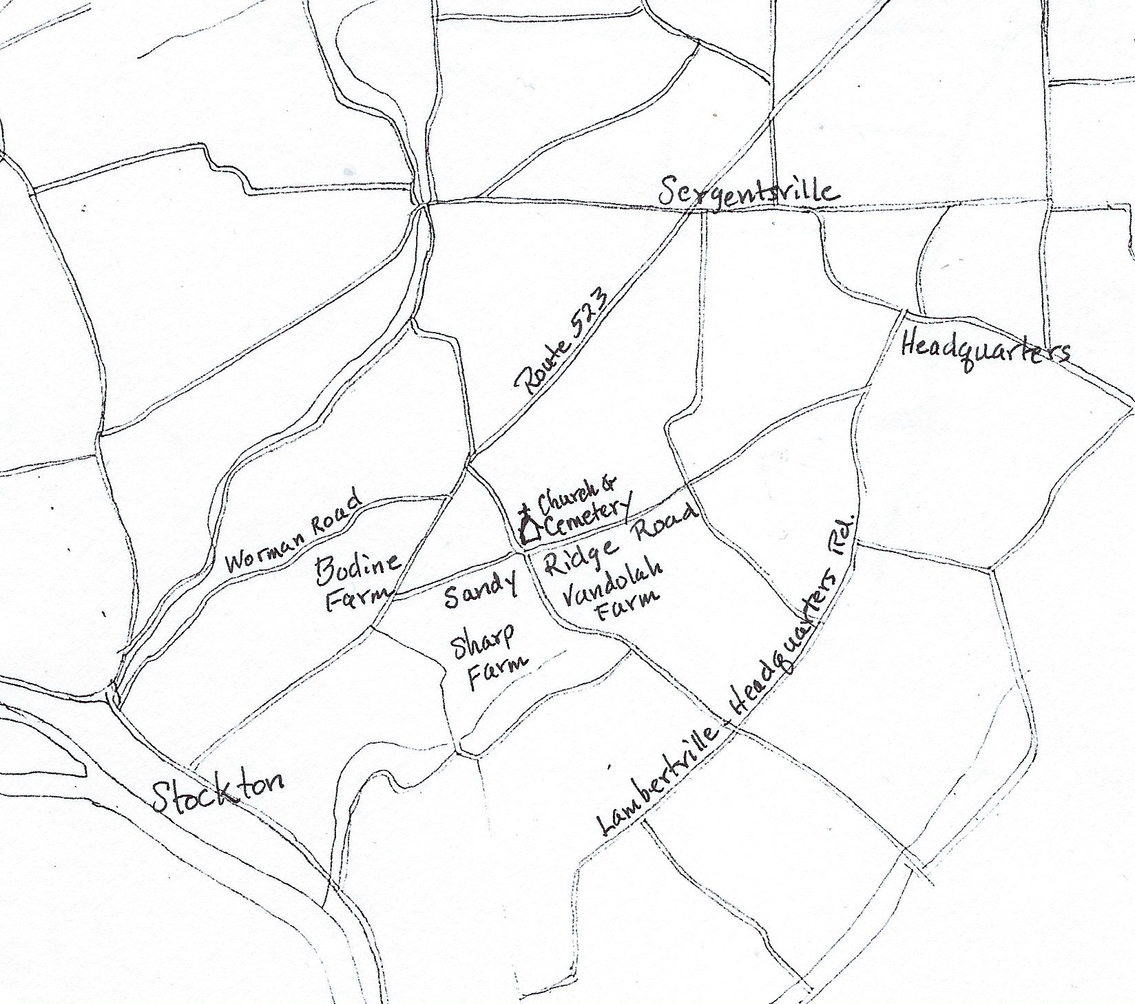
Just to clarify, the road starts at Route 523, and ends in what today is called the Lambertville-Headquarters Road. The “Big Woods” were discussed in the previous post. Mr. Bush wants us to imagine we are standing at the intersection of Sandy Ridge Road and Route 523.
The Bodine Farm
To your left, as you turn from the Stockton road, lies the farm now owned by Mary H. Bodine and Lucy L. Bodine, noted for the finest grove of whiteoaks to be found in the vicinity. In 1844 most of this farm, together with other lands, was conveyed by Thomas Holcombe to Benjamin Bodine. In 1876 it was conveyed by William Bodine and Cornelius Bodine, Executors of Benjamin, to Samuel R. Bodine, son of William and father of the present owners.
This is the first of the several properties that Mr. Bush describes in this article. The Bodine farm was located on the west side of Route 523, opposite the intersection with Sandy Ridge Road. Mr. Bush apparently considered it part of Sandy Ridge.
Mary (1784-1943) and Lucy (1876-1951) Bodine were the unmarried daughters of Samuel Reading Bodine (1845-1920) and Sarah L. Larison (1844-1920). Before I look into the early deeds for this property, I must share a marvelous story about this couple that appeared in the Hunterdon Republican on December 15, 1897:
News from Sandy Ridge: Samuel R. Bodine and wife, Sarah L. of Sandy Ridge, were much surprised on Saturday evening. A young lady friend was spending the evening with their daughter Miss Lucy L. Bodine and being musically inclined, kept the organ going at a rattling pace all the early part of the evening. Samuel’s brother, Charles Bodine, had also called and the brothers were doing their best to talk right through the noise the young ladies were making. At 7:30, a knock was heard and in bounded their other daughter, Miss Mary H. Bodine, a professional nurse, of Brooklyn, so unexpectedly. But greetings had scarcely been exchanged when after he[r] came trooping in, their friends and neighbors to the number of about 100. The good people were taken completely by surprise; but they remembered that it was the 25th anniversary of their marriage and knew what it all meant and why the girls had been so enthusiastic over music and Charles so full of talk. The ruse worked so well that the approach of 20 or 30 wagons had not been heard at all. The affair was voted a success by all concerned. Presents were prohibited, but some beautiful and costly ones were brought anyway.
Mr. and Mrs. Bodine must have been highly regarded for so many “friends and neighbors” to come celebrate their anniversary.
But back to the chain of title provided by Mr. Bush, when he wrote: “In 1844 most of this farm, together with other lands, was conveyed by Thomas Holcombe to Benjamin Bodine.”
I must state, with regret, that although Mr. Bush was right that Thomas Holcombe sold a farm to Benjamin Bodine in 1844, he was wrong to think that it was the original farm located across from Sandy Ridge Road. On May 8, 1844, Thomas P. Holcombe & wife Catharine of Delaware Township sold 97.34 acres to Benjamin Bodine, also of Delaware Township, for $2,920.20.1 This was part of a larger tract that Holcombe had bought from Peter Miller of Easton in 1841.2 By plotting this deed I discovered that the property was what today is known as the Bodine farm, further south on Route 523—not the farm Bush that was thinking of. It was part of the 280 acres owned by John Prall, Jr., and originally part of the Howell tract. It was also just south of the farm that was given to Eliza Scarborough by Jacob Howell. (See Howell House, part three for a description of this property.)
So where did Benjamin Bodine get his original farm from? There is no deed recorded for it, but it must have come from his mother’s family, the Ents.
Benjamin Bodine
Benjamin Bodine, born in 1794, was the youngest child of Peter Bodine and Sabilla Ent. (See the Bodine and Ent Family Trees.) Exactly when Peter Bodine showed up in Amwell Township is hard to say. The family is French, but moved to New Jersey in the early 18th century. Peter Bodine, born in 1756, was certainly present in the Sandy Ridge vicinity by 1781, which we know from a deed of that year.
In 1815, Benjamin Bodine married Catharine Ent (c.1795-1882), daughter of John and Rebecca Ent. (Benjamin’s mother Sabilla Ent Bodine was a first cousin once removed from his wife Catharine Ent.)
Benjamin and Catharine Bodine had four children: William, Cornelius, Catharine and Lambert. William married Delilah Ann Rittenhouse; Cornelius married Miriam Chapman Romine and Catherine married Samuel Wolverton—a good example of Hunterdon families intermarrying. Son Lambert died unmarried age 28 in 1863, perhaps in the Civil War.
Benjamin Bodine began acquiring property the same year he married, when he bought a woodlot in the Williamson tract on Pine Hill Road. His first recorded purchase in the Sandy Ridge neighborhood, in 1822, was for another woodlot on the Stockton Road.
In 1829, he bought three fairly small lots from John & Elias Conover, being land previously owned by his uncle, Daniel Ent, who had gone into debt. These lots either bordered or were very near to the farm Mr. Bush was writing about.
The Dimsdale Tract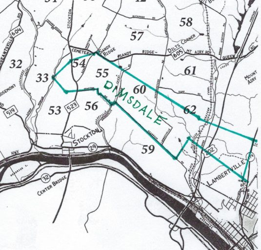

Let’s jump back a little. Benjamin Bodine’s farm, the one across from Sandy Ridge Road, was once part of the Dimsdale tract. It was part of the 410 acres sold to Valentine Ent in 1750.3 The deed included a long recital describing how it got from Dimsdale to the seller, John Lambert of Kingwood, who apparently had little interest in it and sold it to Ent a short time after he acquired it.
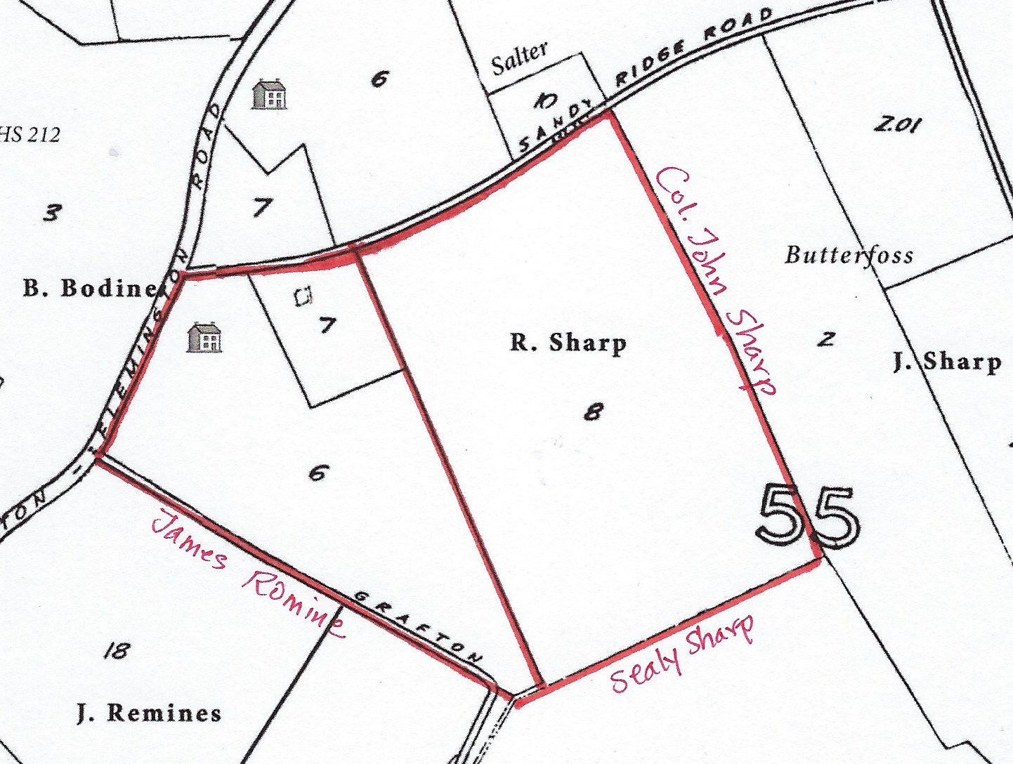
Plotting that deed showed me that Ent was sold the northern half of the 831-acre Dimsdale tract that ran from Shoppons Run on the north all the way south to the Alexauken Creek, and included all the property southeast of Sandy Ridge Road, between Grafton Road on one side and Sandy Ridge-Mt. Airy Road at its northern point, as you can see from the map. And as mentioned before, it also included land on the northwest side of Route 523, where the Benjamin Bodine farm was located.
Valentine Ent
Valentine Ent, the purchaser of 1750, was the son of Hendrick Ent. (See The Ent Family Tree) He married Susannah Moore about 1745 and was the father of Sabilla Ent (1759-1825), who married Peter Bodine about 1777. It appears that Peter Bodine came into possession of the northern part of the Ent tract, sometime before the Revolution. No doubt he acquired the property from the estate of his father-in-law, Valentine Ent.
Valentine Ent wrote his will on March 14, 1770, when he was about 55 years old. He described himself as a tanner of Amwell. I have not seen the original will, but the abstract available in N.J. Archives seems odd. He made financial bequests to his children and wife, but seems to have said nothing about the disposition of his real estate. Apparently he left it to his executors, who were his wife Susannah, and her brothers (which he called “my brothers”) Peter and Daniel Moore.
With twelve children to divide the property between, the executors came to the only possible conclusion. The property must be sold and the proceeds divided between the heirs.
Valentine Ent died on July 25, 1770, but it took his executors eight years to decide to put the farm up for sale. Here is their advertisement:
“TO be Sold by publick vendue, on Wednesday, the 25th Day of November next, A Plantation containing 410 acres, late the property of Valentine Ent, late of Amwell deceased, lying within one mile of Howell’s ferry; whereon is a good stone dwelling-house, a good Dutch barn, a large bearing orchard, a convenient tan-yard, with a good stone currying shop. One half of said plantation is cleared and in good fence, fifteen acres of good meadow, and more may be made. The whole is well watered. The conditions will be made known at the time and place of sale, and an indisputable title given by Susannah Ent and Peter Moore, executors. Amwell, Hunterdon county, Sept. 23, 1778.”4
This makes it is clear that Valentine Ent never divided smaller lots out of his 410-acre plantation. But his executors, widow Susannah and her brothers Peter and Daniel Moore, did. On August 13, 1781, the executors sold a lot of 16.5 acres to Peter Bodine and his wife “Bilah,” for £50, the lot bordering George Wilson, Benjamin Howell and Sarah Ent, which puts it on the west side of Route 523. I was not able to exactly locate this lot on the tax map and suspect that it became absorbed in other properties in the 18th century. There must have been another deed from the executors to Peter and Bilah Bodine for the farm across from Ridge Road, but it was not recorded. And there was no deed recorded from Peter and Bilah Bodine to their son Benjamin, for that farm.
The rest of Valentine Ent’s farm seems to have gone to his son Peter Ent. In 1786 he was taxed on 205 acres, four horses, 5 cattle, 1 hog and one tanyard. A deed of 1804 showed him bordering property of John Lambert, Esq., who was on the southern boundary of the Ent tract.5
Back to Benjamin Bodine
Benjamin Bodine (1794-1875), son of Peter Bodine and Sabilla Ent, married Catharine Ent on Sept. 16, 1815. The marriage was performed by Rev. Charles Bartolette, but it took place before the Sandy Ridge Baptist Church was built. I have not found a record to show how Catharine was related to the Amwell Ents, but she must have been.6
The additional farms that Benjamin Bodine purchased along Route 523 were occupied by his son William by the time the Beers Atlas was published in 1873.
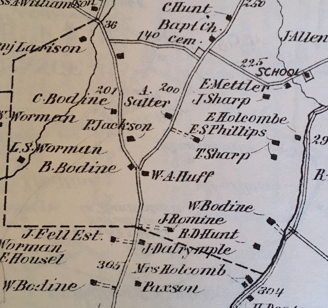
On the Atlas you can see “B. Bodine” on the west side of Route 523, just north of the turnoff for Sandy Ridge, and going south, “J. Fell Est.” which was the home of Eliza Scarborough, and then “W. Bodine” at the first house north of Stockton. That was Benjamin’s son William Bodine (1819-1886).7
Benj. Bodine wrote his will on April 18, 1869 and died on February 17, 1875 age 80. His wife survived him, dying on March 27, 1882, age 87, and was buried next to her husband in the Sandy Ridge Cemetery.
In his will, Benjamin Bodine ordered his executors to sell his real estate after this death. This is surprising because, as it turns out, his son William wanted it to stay in the family. But he was named one of the executors, along with his brother Cornelius, and they were obliged to sell the farm at a public sale. Once again, the old trick was employed. William’s son Samuel R. Bodine bought the farm of 58.27 acres for $6,905. And on the same day, Samuel R. Bodine sold the same farm (in a private sale) to William Bodine for the same $6,905.8
Mr. Bush wrote that the farm had been conveyed to Samuel R. Bodine, and he is correct, but he did not mention that it was conveyed twice! The first time in 1876, and the second time in 1880. It was still 58.27 acres, but Samuel paid only $6,000 for it.9
Samuel Reading Bodine died in 1920, age 75. His wife Sarah L. Larison (daughter of Benjamin Larison and Hannah Holcombe) died the same year, age 76. The couple had been married almost 50 years. They both were buried in the Sandy Ridge Cemetery. It was undoubtedly after this that their daughters Mary Hannah Bodine (1874-1943) and Lucy L. Bodine (1876-1951) got the property.
The Corner House
On the corner at your right is the smaller farm now owned by Mary H. Bodine. This farm, then containing 28.55 acres and including the John H. Bray lot, was conveyed by Robert Sharp to Tobias Shadinger in 1853. Shadinger conveyed 22.45 acres of his purchase to David Howell in 1855, and on the same day conveyed the other 6.10 acres—the John Bray lot—to William Godown, who erected the buildings thereon and made it his home for several years.
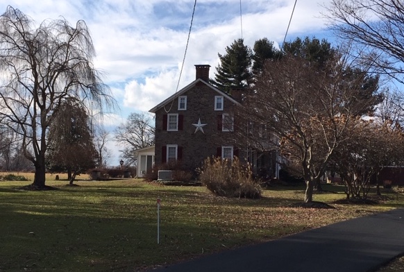
Bush is discussing the lot on the corner of Route 523 and Sandy Ridge Road, the house that always has a wonderful array of flowering plants in window boxes at the windows and hanging from a fence. In the warm months, it is a lovely bright spot along the Stockton road. Mary H. Bodine, one of the two daughters of Samuel R. Bodine and Sarah Larison, owned this property in 1930 when Mr. Bush was writing.
When Mr. Bush wrote that the farm “then” contained 28.55 acres, he was probably referring to 1853, when Robert Sharp sold it to Tobias Shadinger. The sale was made by Robert & Elizabeth Sharp of Delaware Township, and the price was $898.50 for a lot of 28.46 acres bordered by the great road from Centre Bridge to Flemington, Cornelius Bodine, the Sandy Ridge Road, Robert Hunt, and “Mr. Romine.” There was no recital. Mr. Bush continued the chain of title:
In 1867 [David] Howell sold his property to Charles Stillwell, father of the Baptist preacher, Herbert Stillwell. Charles is said to have projected the erection of other buildings on the beautiful knoll at a considerable distance back from the Ridge Road, where he could enjoy a fine view of the river and of the distant hills. However, he finally divided his lands, conveying the dwelling and 4 acres of land along the road to Mary C. Stout, March 13, 1861, “reserving a right of way from said Public Road to the lands lying in the rear of the lands conveyed, until a Public Highway shall be opened which shall afford a success [sic] thereto.”
Actually, the sale by David Howell and wife Mary to Charles Stillwell of a lot of 22.45 acres took place on April 3, 1857. The property cost $1,150.10
On the same day he [Charles Stillwell] conveyed about 20 acres, the “lands lying in the rear,” to Ezekiel Everitt, Joseph Everitt and Richard G. Everitt. Whether or not Stillwell had actually begun building on the knoll is not certain. But Thomas Everitt, a brother to the original purchasers, did soon after almost complete a modest but substantial stone house on that desirable spot. Then the prospective bride who was to occupy the new house, was taken sick and died. The house was never completed. The roof fell in and the floors rotted away, but there stood the walls, defying time and weather, until recently torn down. And the prospective bridegroom remained single to the end of his days.11
This Mary C. Stout was a daughter of Rev. Joseph Wright, who owned and occupied the lot, now owned by the Germans, lying back of the Bodine farm, having apparently bought it in 1850. He was for several years pastor of the Sandy Ridge Church, and at one time teacher of the Van Dolah School. We find that in 1868 Mary C. Stout conveyed her lot to Mary A. Hoff, with the same reservation; and further, that Thomas and Ezekiel Everitt conveyed the rear parcel to Mary A. Hoff in 1880, bringing the two lots together again as one farm. About this time the anticipated highway was opened and the reservation was annulled. Mary A. Hoff held the property until 1908, and then sold it to Ambrose B. Griffith. Griffith sold it to George C. Eick in 1915, and Eick to its present owner in 1917.12
This very thorough history of the corner lot will stand on its own, for I am anxious to discuss the next farm along the road, the farm that Bush himself once owned.
The Bush Farm
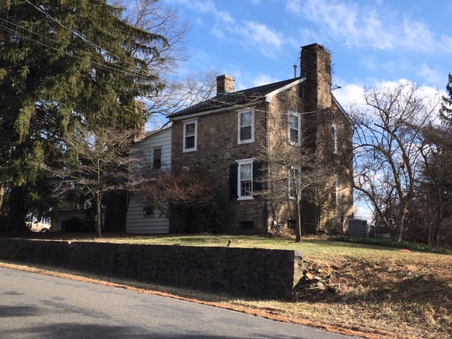
East of this and of the Godown property, lies the fruit and poultry farm of Percy W. Bush, which was originally a part of the old Robert Sharp farm.
The executors of William Sharp conveyed this and other lands to the late Robert Sharp in 1850. In 1851 he erected the house and barn still there, both remodeled, and lived there until 1861. Then, selling the farm to Frederick S. Phillips, he removed to Stockton for the remainder of his life. In 1877, Nelson V. Young and William Bodine, assignees of Phillips, conveyed the property to Philip E. Rockafellow, whose widow and son John W. Rockafellow, father of Postmaster Philip E., of Stockton, conveyed it to Egbert T. Bush in 1892, and he to the present owner [Bush’s son Percy Bush] in 1917.
Of all the names in this paragraph, the ones most of interest to me are Robert Sharp and William Sharp. Robert Sharp turned up in another of Mr. Bush’s articles, “Brookville and Up the Hollow,” in which he wrote: “Robert Sharp, 2nd, lived in the upper tenant house on the Colonel Sharp lowlands, and did the farming from 1844 to 1850.” That Robert Sharp, Jr., who sold the corner lot in 1853, was the son of Col. John Sharp and Maria Holcombe. He resided in their tenant house before he acquired the Bush farm from William Sharp.
Let’s look a little closer at the Sharp Family. (I have added a Sharp family tree to the Families page.)
Robert Sharp
Robert Sharp (1823-1881) was the son of Col. John Sharp and Maria Holcombe. His maternal grandparents were Thomas Holcombe and Mary T. Holcombe. This was not the same Thomas Holcombe who bought the old Prall tract and sold it to Benjamin Bodine. That Thomas was born in 1801. Robert Sharp’s grandfather Thomas Holcombe was born in 1754, and was the great uncle of the younger Thomas.
Robert Sharp married Sarah Prall about 1843. (She must be related to John Prall, Jr., but I don’t know how.) They had four children: Cornelia Ann c.1844; Gershom Lambert Sharp, 1845-1923; Mary Hannah Sharp, 1847-1930, who married Mathias W. Buchanan, Jr.; and Sarah Sharp, 1851-1937, who married Daniel D. Sperling.
As Mr. Bush wrote, Robert Sharp acquired his farm in 1850, when he bought it from the estate of William Sharp, deceased. It was then 84 acres, and sold for $2,250.13 It bordered land of Col. John Sharp (Robert’s father), Sealy Sharp (his uncle), the road from Sandy Ridge to Centre Bridge (Sandy Ridge Road), the road from Sergeantsville to Centre Bridge (Route 523), Benjamin Bodine, and James Romine.
The executors of William Sharp, dec’d, Thomas Sharp and John Barber, sold the southern half of the Sharp estate to William’s brother Sealy Sharp, who immediately sold it to William Sharp’s son (and Sealy’s nephew) Thomas Sharp.14
There was no recital in the deed to tell us where William Sharp got his property from. So let’s take a closer look at this William Sharp. He was born March 23, 1782 to Robert Sharp, Sr. and Rachel Ent, and was the older brother of Col. John Sharp.
In 1806 he married Esther Butterfoss (1788-1868), daughter of Daniel Butterfoss, Sr. and Esther Ent. Esther Ent was the sister of William’s mother Rachel Ent. They were daughters of Valentine Ent and Susannah Moore, so William Sharp and wife Esther Butterfoss were first cousins.
William and Esther Sharp had four children: Thomas (1807-1884) who married Rebecca Lambert; George W. Sharp (1812-1876) who married Elizabeth Vandolah; Robert, born about 1815; and Daniel Runk Sharp (1818-1894) who married Mary Ann Rounsavel.
William Sharp died on May 16, 1834, at the relatively young age of 52. His father Robert Sr. died on January 31, 1833, at the relatively advanced age of 84. Which means that William lived just barely long enough to profit from his father’s last will & testament, dated August 10, 1831. In the will Robert Sharp left to his son William, who was named an executor along with his brothers Sealy and John Sharp, “my plantation whereon I now live in the township of Amwell bordered by Furman Romine and others of 210 acres.”
It should also be noted that Sharp left to his son John “my plantation called the Butterfoss farm in Amwell bordering late Henry VanDolah of 130 acres.” That farm was located just to the east of the Bush farm.15
The history of Robert Sharp’s plantation was described by Mr. Bush in his article “Old Headstones and Headlines:”
We are told that the original Robert Sharp farm—including the Col. John Sharp farm, later owned by Elijah Holcombe and still later by his daughter, Cornelius A. Hillier, and much other land—was conveyed by William Biddle to Robert Dinsdale [sic, Dimsdale], by Dinsdale to Theabald Ent, and by Ent to his son-in-law, Robert Sharp.
This chain of title from Mr. Bush does not quite match the one provided in a deed of 1750.16 That recital is amazing, and very difficult to read. The jist of it was that Robert Dimsdale and Nicholas Lucas got a tract of 831 acres surveyed, that Dimsdale bought out Lucas’ rights in the tract, that sometime between 1724 and 1750, Robert Dimsdale’s heir John Dimsdale sold the entire tract to John Lambert of Kingwood. The deed itself, dated July 27, 1750, was a conveyance from John Lambert to Valentine Ent (not Theabald Ent), consisting of the northern half of the Dimsdale tract, or 410 acres.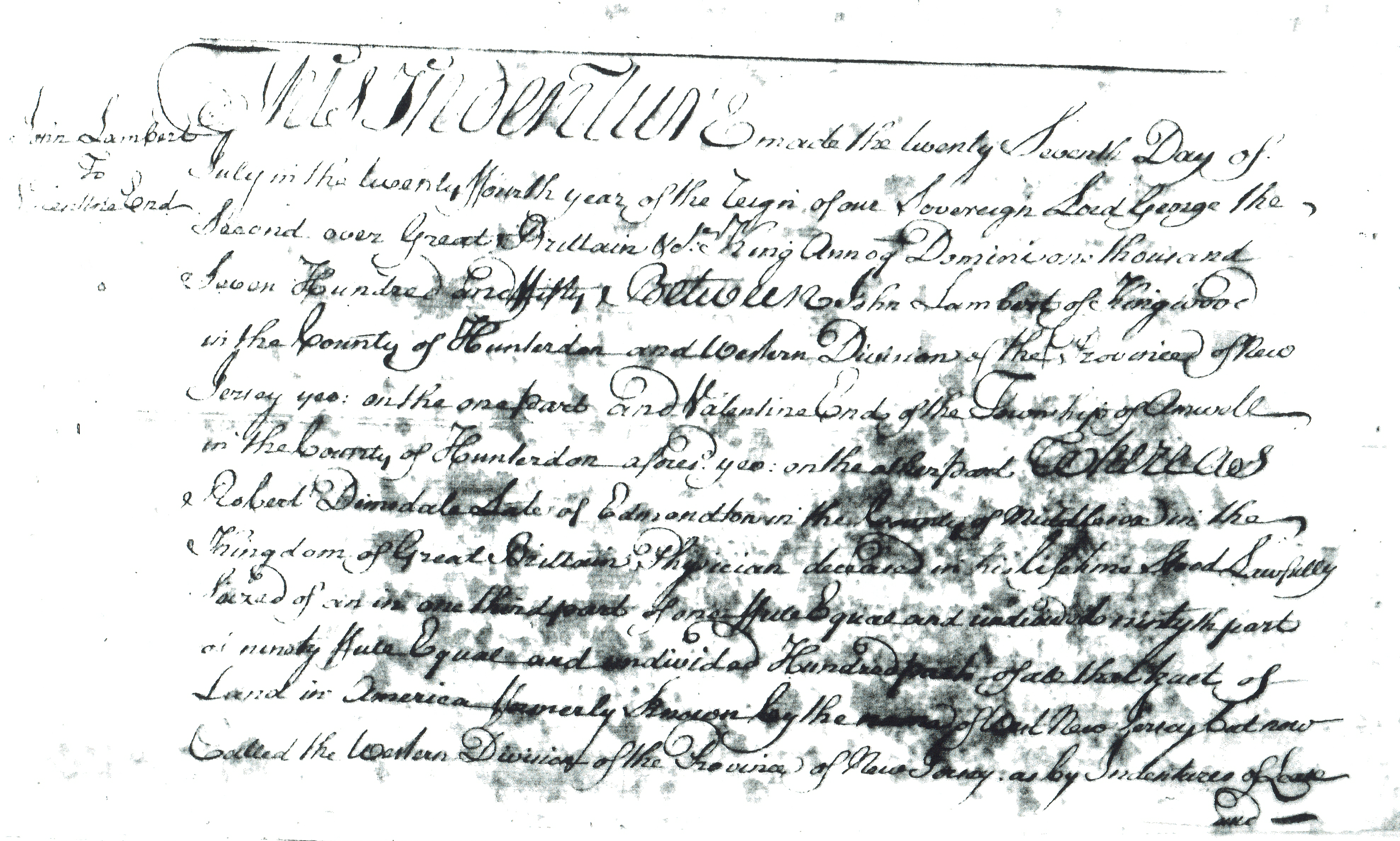 What Mr. Bush was referring to was a different conveyance, dated August 24, 1724,17 in which land claimed by William Biddle was resurveyed to William and John Dimsdale. It described two tracts of land, one of 1146 acres, which was the larger tract bordering Lambertville; the other of 820+ acres, being the one at Sandy Ridge, and bordering the “Allishocking” creek, land of Samuel Green and other land of William Biddle. Bush continued:
Also that this extensive tract lay west of the old Bool’s line, which ran from Bool’s Island southward, dividing the Van Dolah lands from the Sharp tract, the Kitchen-Case farm from the Senator John Lambert tract, and thence beyond the present boundary of Hunterdon County. But these early transactions are too far back for either confirmation or correction by our records.
This business about “the old Bool’s line” had me stumped. First of all, how could it run southward from Bull’s Island? That would take it across the river into Pennsylvania!
What Bush was describing was the very long boundary line that began at the Sandy Ridge Church. The first hundred feet or so of Sandy Ridge-Mt. Airy Road runs along that line before it curves to the east. The Dimsdale tract is on the west side of that line, and John Way and William Biddle are on the east. It certainly does not go anywhere near Bull’s Island. It does however, divide the Sharp farm from the Vandolah farm.
Here is the Sandy Ridge area as mapped by D. Stanton Hammond. The top left of the “Dimsdall” tract is where Benjamin Bodine’s farm was located.
 As you can see, Bull’s Island is nowhere close to Sandy Ridge. There is no proprietary border line that goes in that direction. The only line I can think of that goes all the way to Bull’s Island is the Lotting Purchase line which was surveyed by Richard Bull in the early 1700s, and is far to the west of the Dimsdale tract.18
Mr. Bush also wrote about Robert Sharp in his article “Brookville and Up the Hollow.”
“The pioneer Sharp in the Hollow was Robert, who settled on what was later the Thomas Sharp farm during or soon after the Revolution. That farm extended from below Brookville Hollow road northward across the road passing the Sandy Ridge Church and ending when it came to the Stockton-Sergeantsville road. The descendants say that this Robert Sharp paid $100 in Continental money for a set of china dishes, a few relics of which were recently sold at a public sale in Brookville. The value of a dollar in Continental money at the time of the purchase is not known.”
What Mr. Bush was describing was the northern half of the original Dimsdale tract, a part of the 410 acres sold to Valentine Ent in 1750. His only mistake was thinking it ended at the Stockton-Sergeantsville Road. In fact, it continued northwest to encompass the farm that was later sold to Benjamin Bodine.
Peter Ent
The eldest surviving son of Valentine Ent and Susannah Moore was Peter Ent (1749-1829). He was a veteran of the Revolutionary War, just as Robert Sharp was. On January 27, 1776, he married a woman named Susan Kent. Both were residents of Hunterdon County at the time, but I know nothing about her family.19 Peter and Susan had at least two children, a daughter Sarah or Susannah (1784-1854) who married William S. Brewer, and a son Charles (1788-1849) who married Elizabeth Mears, and moved away from Hunterdon.
By 1804, Peter and Sarah Ent may have also been thinking about moving west. On May 17, 1804, they sold their farm of 200 acres to Robert Sharp of Amwell for $5,466.67.20 Bordering owners were John Lambert, Daniel Butterfoss, the road from Howell’s ferry to Flemington, a small lot owned by Daniel Ent, land of James Romine and Charles Ent. The 200 acres was the core of the Valentine Ent farm. It did not include land owned by Benjamin Bodine, nor the farm sold to Daniel Butterfoss.
In 1825, a land warrant for 80 acres in Ohio was granted to Peter Ent for land he purchased on April 24, 1820. I assume he had left Hunterdon County several years before that. The letters of Sen. John Lambert include a passing mention of Peter Ent. A letter dated February 9, 1807 to his granddaughter Susan reads: “What a man Capt’n ent is, I did not expect he would so soon forget me.” That was all he said. What was the story behind that? It has been written that Capt. Ent died on January 29, 1829 and his wife Sarah on May 14, 1821. I assume they were living in Ohio and do not know where they were buried.
Back to the Bush Farm and Robert Sharp
So far we have land passing from the Dimsdales through a few intermediaries to John Lambert to Valentine Ent to Peter Ent to Robert Sharp.
Robert Sharp was born in England on November 16, 1748, parents not known. He was an Anglican and worshipped in the Anglican church run by Rev. Wm. Frazer in Ringoes. He was a big supporter of Rev. Frazer, and had some of Frazer’s letters among his papers. But even though he worshipped in the Church of England, he still fought in the Revolution on the patriots’ side. He was living with Samuel Holcombe at the time and served in his stead.
After the war, he settled on property at Sandy Ridge and married into the Ent family. Rachel Ent (c.1757-1849) was the seventh of twelve children of Valentine Ent and Susannah Moore, and sister of Peter Ent. She and Robert Sharp had eight children of their own, most of them marrying into local families.
Egbert Bush tells us more about Sharp in his article “Old Headstones and Headlines:”
Tradition persistently tells us that the original Robert Sharp had a perplexing habit of leaving his home some time in May of every year, to be gone for several days, perhaps a week or more. Nobody ever knew where he went or why the secrecy. But it was noted that on each return, he brought with him a bag of gold and a bag of silver, making no effort to conceal what he had secured and no explanation as to its source. That was Robert’s secret and was destined to die with him; but the mystery survives.
One may safely conclude that Robert Sharp died a very rich man. His will of April 10, 1831 left several monetary bequests to children and grandchildren. As mentioned before, he died on April 10, 1831 age 84, and Rachel Sharp died on January 25, 1849, age 92. The couple were not buried in the Sandy Ridge cemetery. According to Mr. Bush, in a separate article (“Runks and Sharps Are Sleeping There”), they were buried in a small family cemetery on the farm of Robert Fisher in West Amwell. Their son Sealy Sharp, who died on April 13, 1854, age 55, was buried with them. The cemetery is not included on Find-a-Grave, and the stones are probably no longer to be found. How the Sharps ended up there is a real mystery to me.
This is not the end of Mr. Bush’s article on Sandy Ridge, but it is the end of this article. I do regret that I so often chop up his articles like this, but it cannot be helped. There will have to be a Sandy Ridge part five.
Footnotes:
- H. C. Deed Book 82 p. 315. ↩
- H.C. Deed Book 75 p. 389. ↩
- West Jersey Proprietors, Deed Book L p. 445. ↩
- Newspaper Extracts, Documents Relating to the Revolutionary History of the State of New Jersey, vol. 2 p. 454. ↩
- H.C. Deed Book 9 p. 344. ↩
- If I were more thorough, I would have gone to the County Clerk’s Office in Flemington and looked up the marriage record recorded there, in Book 2 p. 78, rather than rely on the list of marriages compiled by Hiram Deats. It might contain a clue about Catharine’s family. ↩
- After his death, the farm of 95 acres was conveyed to his son Wesley B. Bodine, who died in 1910. I could go one discussing the Bodine farms, but that gets me off course. ↩
- H.C. Deed Book 163 p. 617, 622. ↩
- H.C. Deed Book 200 p. 247. ↩
- H. C. Deed Book 117 p. 265. ↩
- This sad story begs to be expanded on, but I have a lot of difficulty with the Everitt family, as they repeated given names too frequently to allow one to sort them out. ↩
- As described in H.C. Deed Book 321 p. 664. ↩
- H.C. Deed Book 97 p. 565. ↩
- Mr. Bush wrote about Sealy Sharp in his article “Runks and Sharps Are Sleeping Here,” which I have not yet published. ↩
- Mr. Bush does not discuss this farm in this article. Daniel Butterfoss sold it to Robert Sharp in 1825. The Butterfoss family has gotten passing attention on this site, but deserves a more extensive article. ↩
- West Jersey Proprietors, Deed Book L fol. 445. ↩
- West Jersey Proprietors, Deed Book A fol. 125. ↩
- To learn more about the Lotting Purchase line, see “Richard Bull, surveyor,” and “John Reading and the Creation of Hunterdon County.” ↩
- Documents Relating to the Colonial History of the State of New Jersey, vol. xxii, Marriage Records, 1665-1800, by William Nelson, 1900, p. 232. ↩
- H.C. Deed Book 9 p. 344. ↩
Dennis Bertland
February 3, 2019 @ 10:49 am
Another very informative article Marfy, I wondered, do you have any idea on where Valentine Ent’s farmstead might have been located? It is great when one of these descriptive, early newspaper adds can be tied to a specific property.
Marfy Goodspeed
February 3, 2019 @ 4:34 pm
I have no idea where Valentine lived. Egbert Bush might have had an idea, but didn’t write about it. My best guess would be that his original house is buried inside what seems to be a later house, perhaps the one occupied by Robert Sharp. I haven’t see the original version of Ent’s will; the abstract I have says nothing about how he wanted his property dispersed. That’s the first place to look, I should think.
Tom
October 16, 2021 @ 7:02 am
Love the history. In the 1970’s as a child I lived in a stone house with a Dutch barn of of Sandy ridge mount airy road just south of sandy ridge church. I believe it is the one described above in the advertisement for the sale of the Valentine Ent property. Any other history you may have of the property you could point me to would be greatly appreciated.