In my previous post (A Shrinking Township, part one), I wrote about a petition in 1896 to take a large chunk out of Delaware Township and give it to East Amwell Township. That petition was signed by two East Amwell residents, William H. Manners and Simpson Sked Stout. This post will describe these two, as well as the journey the bill took through the legislature, and the property owners who were affected by it.
Notice of the proposal by Manners and Stout was published in the Hunterdon Republican on November 18, 1896, but the newspaper failed to announce that the legislation was passed the next year, on or about April 17, 1897.1
Manners & Stout
Who were these men who wanted to expand East Amwell into Delaware, Raritan and West Amwell? A look at their backgrounds sheds some light on the subject.
William Henry Manners (1840-1906), son of Jacob S. Manners and Ann Maria Blackwell, married Jennie Schenck Drake (1849-1886), daughter of Reuben A. Drake and Mary Voorhees. After the death of Jennie Manners, he married second, in 1888, Cornelia T. Nevius (1853-1934), daughter of Jacob Nevius and Catherine Schomp. He had two children by his first marriage and three by his second. About the time of his first marriage (about 1875), Manners purchased a tract of 116.56 acres northeast of Ringoes, on the road from Ringoes to Wertsville, from his brother Peter Van Dyke Manners.
Following the Civil War, Manners got involved in the Republican Party of Hunterdon County. In 1878 at the party convention, he was chosen to serve on the party’s executive committee, which consisted of members from every township.2
It was probably through party activities that Manners became acquainted with Simpson S. Stout. On August 12, 1880, “The Republican Voters of East Amwell” organized a “Campaign Club” and Wm H. Manners, Simpson S. Stout and Dr. Amos M. Hart were chosen for the executive committee. Also Simpson S. Stout was chosen as Treasurer.
Simpson Sked Stout (1840-1899), son of Capt. Nathan Stout and Mary Ann Fisher, married in 1884, Julia Hinkle Smith (1856-1943), daughter of Robert Reading Smith and Rebecca Young. They had no children.3 The Stout homestead farm of 160 acres was also located on the road from Ringoes to Wertsville, about two miles from the village. Stout owned several other properties, but none of them were located in that section of Delaware township that got transferred to East Amwell.
In October 1880 the Hunterdon County Republican Convention was held to chose a candidate for the upcoming Assembly election, which
resulted in the unanimous choice of Simpson S. Stout, of East Amwell. A committee consisting of William W. Fisher, John S. Williamson, William Case and James S. Fisher, the delegates from East Amwell, were appointed to inform Mr. Stout of his nomination.
Unfortunately for Mr. Stout, it was a typical year for Republicans; Democrats swept the County. No doubt Stout was fully aware of the likely outcome when he accepted the nomination. I imagine that promoting the Hunterdon County Agricultural Society was more to his liking. He also joined “The Grand Army of the Potomac” and annually decorated the graves of veterans.
I rather doubt that Manners and Stout were the originators of the idea to expand East Amwell into Delaware Township. It is more than likely that party operatives planned it out and got the two Republicans to sign the petition. The petition was submitted at the end of 1896 when the Legislature was no longer in session. It was not introduced in the Assembly until February 1897.
The Legislation
In the Assembly: Given the pattern with the earlier West Amwell bill (described in the previous post), it seemed likely that the East Amwell bill, which was labeled Assembly Bill No. 147, would be introduced not by a Hunterdon Democrat, but by one of the Assemblymen from Mercer County. Sure enough, the bill was introduced by a “Mr. Hutchinson.” Elijah C. Hutchinson, Republican of Mercer County, was later elected to Congress. On February 9, 1897, Hutchinson
“introduced Assembly Bill No. 147, entitled, “An act to change the boundary line between the townships of Raritan, Delaware, West Amwell and East Amwell, in the county of Hunterdon.” Which was read for the first time by its title, ordered to have a second reading, and referred to the Committee on Municipal Corporations.”4
The bill got its second reading on February 23rd, and on March 8, Mr. Hogan, Chairman of the Committee on Engrossed Bills, reported the bill as correctly engrossed (a term used in the Legislature for printing up the final version). The bill got its third reading on March 10th, and passed 32 to 10, which means a lot of members did not vote. In 1897, there were 74 Republicans in the Assembly and only 7 Democrats,5 for a total of 81. But even with only half of the House voting on it, the bill was ordered to be signed and passed on to the Senate for its concurrence.
In the Senate: On the same day that the bill was passed, March 10, 1897, the Clerk of the Assembly went to the Senate to present several bills that needed Senate concurrence, among them Bill No. 147.”6 The bill was given a first reading and sent to the Committee on Boroughs and Borough Commissions, and duly reported out without amendment six days later, upon which it was “taken up, read a second time” and ordered to have a third reading.
That was supposed to take place on March 18th, but instead the bill was “laid over.” The bill was again taken up on March 22nd, at which it was again postponed, but later that day given its third reading, after which the bill was voted on. There were 12 votes in favor and 3 against, the three being the lonely Democrats, Senators Barber (Warren), Daly (Hudson) and Kuhl (Hunterdon).
As in the Assembly, not all the Senators voted on the bill. There were only 15 votes altogether, even though there were 21 Senators, one from each county. The six abstentions or absences came from Atlantic, Essex, Morris, Ocean, Sussex and Union Counties. The bill probably had no interest for them as a local matter, but it did have a potential political impact, so I am surprised so many did not vote.
On March 30th, Bill No. 147 was on a list of bills approved by the Senate that were being sent back to the Assembly without amendment. I cannot report on what happened there, as I did not find mention of its passing. It seems that John Snyder, author of The Story of New Jersey’s Civil Boundaries, didn’t either. Snyder wrote that the bill was passed “approximately” on April 26, 1897. Governor Griggs signed the bill on May 4, 1897 and the bill became law.7
The Route
The route described in the new bill was identical to the one used by Manners & Stout in their petition. Here is an aerial photo with the section given to East Amwell shaded in yellow-green and the section acquired by West Amwell in blue.8 (Many thanks to Marilyn Cummings for preparing this map.)
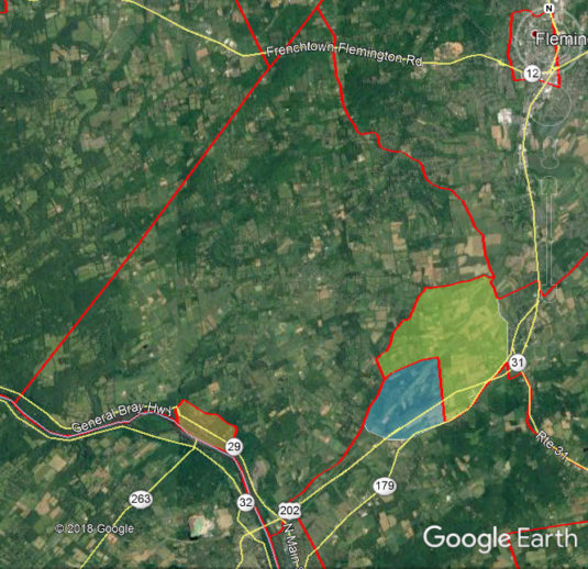
Let’s follow the route of the proposed boundary change:
Beginning at a point in the public road at Larison’s Corner, where the road leading from Flemington to Trenton intersects the line between Raritan Tp. & East Amwell Tp. . . .
This starting point at Larison’s Corner was where Raritan Township and East Amwell bordered each other, at the point where the “Flemington to Trenton” road (today’s Route 202/31) met the Old York Road (Route 179). In this detail of the Cornell Map of 1851, “Pleasant Corner,” located north of the Village of Ringoes, is what was called Larison’s Corner in the bill, and remains as Larison’s Corner today.
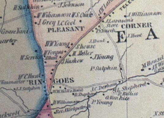
From that starting point, the route proceeds north on today’s Route 202, turns west onto Toad Lane, then north on Route 579, i.e., “the road leading from Ringoes to Quakertown,” also known as the Easton-Trenton Turnpike. The boundary route then goes north a short distance to “the Neshanic creek road,” and then west along this road, running parallel with a branch of the Neshanic Creek. Today that road is called Church Road in East Amwell and Dunkard Church Road in Delaware Township.
At the point where the route reaches “a corner of the farm of Joseph Haines, also a corner of land of Frederick Reeves,” it turns south on today’s Haines Road, but does not go very far before it runs across the farm of “Frank Wagoner” (actually Frank and Emma Wagner) to Route 604.
Joseph Haines lived on the property I have written about previously (The Haines Farm, part 1 and part 2.), at the southeast corner of Dunkard Church Road and Haines Road. The Reeve residence, however, was further east off of Dunkard Church Road, near today’s Rynearson Road, which did not exist in 1896. Reeves did own property across the road from the Haines family, and it is that property that was crossed by the new township line, which proceeded to “where the Bowne Station road intersects the road from Ringoes to Headquarters.”
“Across lands of” means an arbitrary line was being drawn that disregarded roads, which were the usual boundary lines between municipalities. There is lots of room for disagreement with lines like that.
What the bill called Bowne Station Road is today known as Wagner Road, which meets with Bowne Station Road a little north of the station. Bowne Station and Garboski Roads meet the railroad at Barber or Bowne Station, as it was variously known. The railroad originally belonged to the Flemington Transportation and Railroad Co., but is now known the Black River & Western Railroad. (For more about this neck of the woods, see “Let’s Stop Off at Bowne Station” by Egbert T. Bush.)
The route as described in the bill turns left onto Garboski Road, at the time known as Boss Road, even though another part of Boss Road ran southwest from Route 604, intersected with Garboski Road and continued on to Ringoes. It then proceeded northeast along the railroad line to a “corner of lands of the estate of Issachar Hoagland, deceased . . .”
Hoagland’s property extended from the rail line on the north all the way to Old York Road on the south, and the route proceeded south along Hoagland’s western boundary. What amazes me about this course is that Isaachar Hoagland died in 1878! However, his property remained in the hands of his heirs.
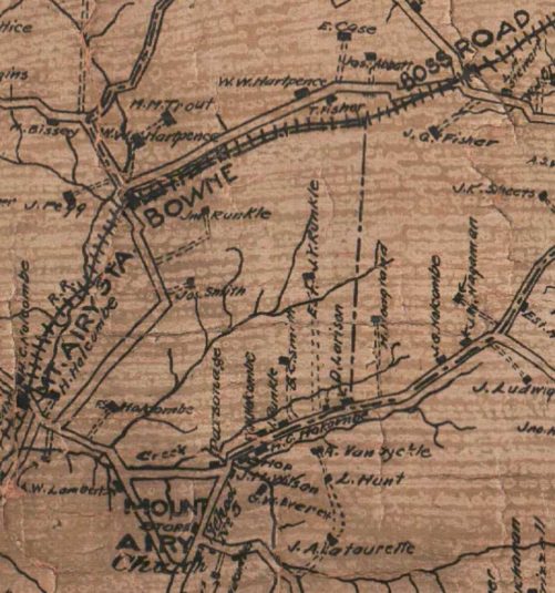
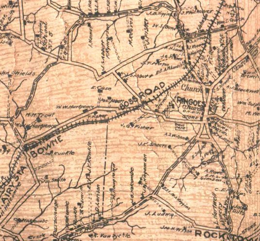
It is odd that this bill says nothing about the area that was transferred from Delaware Township to West Amwell Township at about the same time. It ran from the western side of the Hoagland line to Mt. Airy Station. But there was apparently some uncertainty about it as late as 1902, when the Hunterdon Map was produced. As you can see from this detail, the dotted line showing township boundaries just stops on Old York Road north of Mt. Airy. Curious.
When the new boundary line for East Amwell reached the Old York Road, it turned northeast and continued on to the old boundary line on the southern end of Ringoes, at the intersection of the York Road and Boss Road at the southwest corner of the village of Ringoes, where it continued on to the starting point.
The Owners
On May 4, 1897, Robert Killgore, editor and proprietor of the Hunterdon Democrat, announced as the first item in his editorial column the following:
Governor Griggs last week signed the bill annexing partions [sic] of Raritan, Delaware and West Amwell townships, this county, to East Amwell township, with the hope, no doubt, that he would make East Amwell a Republican township.
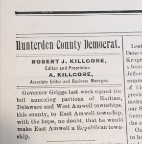
I had combed the Democrat for 1896 and 1897 looking for evidence of outrage on the part of Hunterdon Democrats about this land grab by East Amwell, but I found nothing other than this offhand remark.
This seems very odd. There were plenty of occasions when the Democrat’s editor got vehement in his editorials. I did not expect this offhand cynicism. No self-respecting editor today would be so blasé about this kind of situation. There should have been outrage from Delaware Township at least, but the Democrat was not yet publishing ‘letters to the editor’ on an opinion page.
Unlike Delaware Twp., East and West Amwell were probably pleased. Mr. Killgore’s comment suggests that most of the residents in the affected areas were Republicans. I decided to try to identify the East Amwell owners in 1896 to see if they were active in politics. So I looked in the obvious place—the Hunterdon Republican newspaper, abstracted by Bill Hartman and his team.
In the area that was previously part of Delaware Township, there were 25 properties with identified owners on the Hunterdon County Map of 1902. Here is another detail showing the entire area affected by the bill.9
Using that map and the Beers Atlas of 1873, I went searching for owners in 1896, and for signs in the Hunterdon Republican of their political involvement. Out of all those 25 owners, only five were active enough to get notice in the newspaper. The known Republicans were Joseph Haines, Isaac Haines, Joseph Gardner Bowne, James J. Fisher, “J. G. Fisher” (most likely James Q. Fisher), and possibly William W. Hartpence.
The other male landowners, whose politics are not known, were Alexander H. Landis, James T. Morton, J. K. Bowne, James W. Fisher, William Higgins, Frederick Rynearson, Jacob Schanck Abbott, Frank Wagner, Archibald Trout, Joseph Abbott, Howard Hoagland, James M. Hagaman, John R. Sheets, Austin S. Wilson, Robert Stewart, and William S. Large.
It should be remembered that the women living there, some of them being property owners, could not vote. Women owners were Emma Fisher, Martha Reeves, Emma Wagner, Mary Trout, and Lydia M. Stewart.
You might notice that several Fishers were included. The large property of Peter Fisher (1758-1821) and wife Alice Johnson (1763-1821) was at the heart of the area. In 1820, Peter Fisher left the bulk of it to his son William Peter Fisher. But his eldest son, James Johnson Fisher, owned many other properties here, and son Cornelius Q. Fisher owned the farm on the south side of Boss Road.10
Consequences
So, was this effort to make East Amwell more Republican worth it? The best way to tell is to examine the returns from the following election.
In the election of November 1897 (for the coming session of 1898), Hunterdon County as a whole voted as usual—winning candidates for State Senate and Assembly were all Democrats. But how about East Amwell? Was the boundary change enough to tip the balance there in favor of Republicans?
It appears not. For State Senator, East Amwell favored Democrat John R. Foster of Three Bridges over Republican Charles N. Reading of Frenchtown, 181 to 167, with 9 voting for the Prohibition party. For Assembly, the town voted for the Democrats, David Lawshe and Charles Martens, Jr., over the Republicans, Joseph E. Hampton of Kingwood and Edward C. Johnson of Lebanon, by a margin of 15 votes. Prohibition candidates Ellis E. Roberson of Whitehouse and William J. Bellis of Copper Hill got 9 and 13 votes respectively.11 As a comparison, the vote in Delaware Twp. for the 1897 election was overwhelmingly for the Democrats: Lawshe 364, Martens 350, Johnson 182, Hampton 166.12
The Republicans in East Amwell did better in the previous year’s election (held in 1896 for the 1897 session). That year, the Assembly candidates were Republicans John Q. Holcombe of West Amwell and William G. Simpson of High Bridge, and Democrats David Lawshe of Delaware Twp. and George Martens, Jr. of Tewksbury. (Hunterdon’s State Senator was not up for reelection that year.) In East Amwell, the Republicans got 177 & 168 votes respectively, and the Democrats got 170 and 180, which means that East Amwell split the vote. Winners were Martens the Democrat and Holcombe the Republican.13
So it seems that Killgore’s prediction for party alignment did not hold true for East Amwell. West Amwell was already reliably Republican, with Reading and Haynes [our very own Isaac Haines] beating out Democrats Lawshe and Alpaugh in the 1896 election. In 1897, the Republicans won by a larger margin.
More Consequences
What were the practical consequences? Judging from the minute books of the two townships, the impact was primarily focused on roads. Suddenly East Amwell had some new roads to maintain, i.e., most of Haines Road, the part of Route 604 from Wagner Road to Route 579, Boss Road and its extension known today as Garboski Road, as well as its share of Route 579, Dunkard Church Road, half of today’s Wagner Road, and half of York Road.
This was resolved by the Township Committee on May 14, 1897, when it met with the Delaware Township Committee to divide the roads.14
May 14th, 1897 – The Township Committee met the Delaware Township Committee at Bowns [sic] Station for the purpose of dividing the roads beginning at the Railroad Bridge at Bowns Station to the road leading to the Wagner School House
That school house is today generally known as Moore’s School, located on Route 604. East Amwell also met with West Amwell on April 30th and Raritan Twp. on May 8th to deal with the sections newly acquired from them.
In June, the East Amwell Township Committee faced the music and voted “to raise $400 to be assessed for work on those portions of the roads that were added to the Township from Delaware and West Amwell,” and to “appoint new road supervisors for each section of new roads.”
There was much less about the change in the Delaware Township Minutes. I only found this item from the minute for May 14th, 1897:
The Township Committee met members all present with the Committee of East Amwell Township for the purpose of dividing the road where it was the dividing line between said townships the [word missing?] started at the point at the R.R. bridge to the point at Frank Wagners corner, thence along the road leading from Fred Reeves which is the corner of E. A. & Del. townships to J. B. Higgins measuring both roads, there being but very little difference in the distance of the roads, after consultation Del took the creek road as their portion of the line road and E. A. took the road leading from Bowne’s Station, NJ, Frank Wagner’s corner.15
Even after immersing myself in the route laid out in the bill, I remain a little bewildered by this description, and will say no more about it. In fact, neither township seems to have had anything more to say about it.
Today we take the boundary lines of our municipalities pretty much for granted. And yet, a look at Snyder’s Civil Boundaries will show how fluid they have been.
And the usual reason for the changes was politics. Changing municipal lines was a form of gerrymandering, which had been a common political practice since 1812 or earlier.16 Thanks to the Supreme Court, the practice will continue into the foreseeable future.
Footnotes:
- For a list of the boundary changes of New Jersey’s municipalities and dates when those laws took effect, see John Parr Snyder, The Story of New Jersey’s Civil Boundaries 1606-1968, Trenton, NJ: Bureau of Geology & Topography, Bulletin 67, 1969, pp. 154-159. For those interested in another boundary change in the works in 1896, see the Hunterdon Republican, April 22, 1896, when a very long story was published, reprinted from the Washington Star, concerning a claim by Morris County that the dividing line between Morris and Hunterdon was not “the true line.” I did not see anything further on this in Bill Hartman’s abstracts of the Hunterdon Republican. ↩
- Information about Manners’ involvement with politics came from several issues of the Hunterdon Republican. ↩
- Following the death of Simpson Stout, Julia Stout married second, Rev. Wm Hollinshed (1848-1930), pastor of the Reaville Presbyterian Church. Simpson S. Stout was featured in “Skech of the Fisher Family” by Cornelius W. Larison, 1890 (p. 120). Wm H. Manners was not. ↩
- Assembly Minutes, Feb. 9, 1897, p. 96. I want to thank Heather Husted, Electronic Resources Librarian at the State Library, for finding the Assembly Minutes for me, and for her helpful suggestions. ↩
- Trenton Evening Times, Nov. 5, 1896. ↩
- The following description of the progress of the bill is taken from Journal of the Senate of the State of New Jersey, Volume 121 (1897), pp. 223, 225, 244, 256, 319, 331 and 482. ↩
- The law was published as such in Chapter 163 of Acts of the 121st Legislature of the State of New Jersey, 1897, Chapter 38, p. 70. ↩
- I cannot cite the legislation regarding that section that went to West Amwell as I found no mention of it in the Minutes of the Senate or Assembly. ↩
- The HCHS has two copies of this old map. I tried to get a good photo of the area concerned, and failed. So John Allen came to my rescue and got a beautiful one. ↩
- In the process of researching this article, I have learned a lot more about these Fishers, so much so that I felt it necessary to update my previously published Fisher Tree significantly. You can see the new tree here: Fisher Family Tree. ↩
- NJ Legislative Manual, 1898, p. 389. ↩
- Delaware was divided into a north and a south district. The number given here were the combined totals for both districts. If you compare numbers from the two districts, you get a very different picture. The Democrats did equally well in both districts (178 & 185 votes in the north and 186 & 165 in the south), but the Republicans only got 49 & 52 in the north, but 117 & 130 votes in the south district. Also the north district gave 38 & 37 votes to the Prohibition Party, while the south only gave them 10 & 11. ↩
- NJ Legislative Manual, 1897, p. 398. ↩
- Many thanks to Jim Davidson for looking up the minutes for me. ↩
- Delaware Township Minute Book, 1897, p. 63. Thanks to Jodi McKinney, Clerk for Delaware Township, for digging up the old Minute Book. ↩
- The term came into use in 1812 when Elbridge Gerry, Gov. of Massachusetts, signed a bill that year that would create a new state legislative district around Boston that looked on the map like a salamander. ↩