Not long ago, Dennis Bertland inquired about an old house that might have been located on the William Rittenhouse tract that I recently wrote about (“The Rittenhouse Tavern.” Dennis’ inquiry can be found in the comments section.) It is located in a blank space on the Hammond Map between the Wickecheoke Creek and Shoppons Run. Who did that space belong to?
ferries
When Stockton Was Not So Dry, part two
This part of Mr. Bush’s article deals primarily with the history of the tavern in Stockton, which began its life across the road from the Sharp-Lambert store (part one), but ended it as the Stockton Inn, at Bridge and Main Streets. (As usual, Mr. Bush’s article is in italics and my comments are not.)
Two Lambert Farms
There are two farms in southern Delaware Township that are particularly interesting. They were part of the old Dimsdale proprietary tract north of Lambertville until 1750, when John Lambert, a recent immigrant from Connecticut, purchased it.
A House Divided
Howell’s Tavern House and Ferry House

click to enlarge
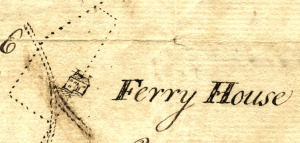
The dotted line in this picture is a survey line, drawn by Reading Howell in 1774, and as you can see, one of the lines goes right through the middle of the house, which is labeled “Ferry House.” Strangely enough, this house has long been known as the tavern house at Howell’s Ferry (Stockton) which I wrote about in “Jacob’s Path, an 1813 Shortcut.” So why was the tavern house called the Ferry House in 1774? And why did the surveyor run a line right through the middle? Therein lies a story.
Federal Twist Road
This is an update and reworking of one of the first articles I wrote for “The Bridge,” the Delaware Township newsletter, in September 1992. The road is part of the Raven Rock neighborhood, so it might be considered an extension of my series on that village.
Painter’s Ferry
This Delaware River ferry was located on the Pennsylvania side at the village of Lumberton in Solebury Township, which is easily confused with Lumberville, further north.1 On the New Jersey side, the ferry began at Johnson’s Tavern near the end of Federal Twist Road, about ¾ mile south of Bull’s Island.
Nattie Saxton Addendums
I have just gotten some information that I must add to previously published posts on Nathaniel Saxton of Raven Rock.
The first will be added to Saxton in Raven Rock, as it concerns a business endeavor of his that I was previously unaware of: wool-carding.
The second addendum will be made to Saxton’s Saxtonville, in which an earlier date is found for the use of the village name of Saxtonville–1811, and we learn that Saxton also ran the ferry just south of Saxtonville.
Both of these interesting items were provided by Betty Davis, daughter of Anton and Bertha Schuck, formerly of Raven Rock. Betty, like her mother, is a life-long student of the history of this area.